


Embraer Prodigy
®
Flight Deck 100 Pilot’s Guide
190-00728-04 Rev. A
382
HAZARD AVOIDANCE
TAWS-B PAGE
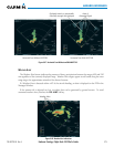
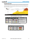
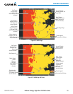
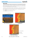
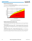
TheMap-TAWS-BPageisspecializedtoshowterrain,obstacle,andpotentialimpactpointdatainrelation
totheaircraft’scurrentaltitude,withoutclutterfromthebasemap.Itistheprincipalmappageforviewing
TAWS-Binformation.Aviationdata(airports,VORs,andotherNAVAIDs)canbedisplayedforreference.Ifan
obstacle and the projected flight path of the aircraft intersect, the display automatically zooms in to the closest
potentialpointofimpactontheTAWS-BPage.
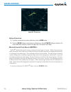
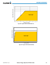
Aircraftorientationonthismapisalwaysheadingupunlessthereisnovalidheading.Twoviewsareavailable
relativetothepositionoftheaircraft:the360°defaultdisplayandtheradar-likeARC(120°)display.Maprange
is adjustable with the RANGE Knobfrom1to200nm,asindicatedbythemaprangerings(orarcs).
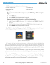
Displaying the TAWS-B Page:
1) Turn the large
FMS
Knob to select the Map Page Group.
2) Turn the small
FMS
Knob
to select the TAWS-B Page.
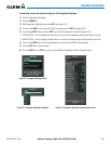
Changing the TAWS-B Page view:
1) Select the
VIEW
Softkey.
2) Select the 360 or ARC Softkey to select the desired view.
Or:
1) Press the MENU Key.
2)
Select ‘View Arc’ or ‘View 360º’ (choice dependent on current state) and press the ENT Key to change the view
Showing/hiding aviation information on the TAWS-B Page:
1) Press the MENU Key.
2) Select ‘Show Aviation Data’ or ‘Hide Aviation Data’ (choice dependent on current state) and press the ENT Key.