


6.1 Chart application overview
With suitable heading and position data from your charts and a GPS
module, your multifunction display enables you to
• Find out where you are.
• Interpret your surroundings.
• Measure the distance and bearing between two points.
• Place waypoints at specic locations.
• Navigate to a specic point.
• Build and follow a route.
• Monitor where you are going.
• Distinguish between xed and moving objects using radar overlay.
• Record where you have been.
• Manage and edit routes and tracks.
• View AIS data.
You can also use your multifunction display to customize your chart
application to your own particular requirements and circumstances.
You can:
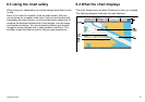
• Alter the way the chart is drawn in relation to your boat and the
direction you are travelling in (chart orientation and motion mode).
• Manage and edit chart data you have entered.
• Control the level of detail displayed on-screen.
6.2 Ensure safe navigation
Ensure safe basic navigation at all times.
This product is intended only as an aid to navigation and must
never be used in preference to sound navigational judgment. Only
ofcial government charts and notices to mariners contain all the
current information needed for safe navigation, and the captain is
responsible for their prudent use. It is the user’s responsibility to
use ofcial government charts, notices to mariners, caution and
proper navigational skill when operating this or any other Raymarine
product.
50 C-Series Widescreen user reference