


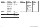

Menu item Description Options
Chart Offset
Allows you to move
the position of the
chart in order to correct
for position errors in
the cartography. This
adjustment is indicated
in the chart application
as a distance north/west
(+ve) or south/east
(-ve) from your vessel
position, to a maximum
of 1000m. When you
press the trackpad right
to select this menu item,
the OFFSET softkey is
displayed, enabling you
to switch chart offset ON
or OFF.
• ON
• OFF (default)
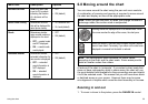
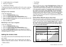
Selecting the cartography setup menu
In the chart application:
1. Press the MENU button.
2. Using the trackpad, highlight the Cartography Setup menu item.
3. Press right on the trackpad to enter the Cartography Setup menu.
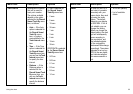
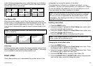
Cartography setup menu options
The following table describes the various options in the Cartography
Setup Menu for your multifunction display.
Menu item Description Options
Chart Display
Determines the level
of detail shown on the
chart.
• Simple
• Detailed (default)
• Extra Detailed
Chart Grid
Determines whether
grid lines representing
longitude and latitude
are displayed on the
chart:
• OFF — grid lines are
NOT displayed.
• ON — grid lines are
displayed.
• OFF
• ON (default)
Chart Text
Determines whether
chart text is displayed
(place names and so
on).
• OFF — chart text is
NOT displayed.
• ON — chart text is
displayed.
• OFF
• ON (default)
Chart Boundaries
Determines whether a
line indicating the chart
boundary is displayed.
• OFF — chart
boundary is NOT
displayed.
• ON — chart boundary
is displayed.
• OFF
• ON (default)
56 C-Series Widescreen user reference