


Note: Radar range synchronization is not available when the
chart motion mode is set to AUTORANGE.
Chart scale and radar range synchronization
You can synchronize the radar range in all radar windows with the
chart scale.
When synchronization is switched on:
• The radar range in all radar windows changes to match the chart
scale.
• ‘Sync’ is indicated in the top left-hand corner of the chart window.
• If you change the radar range, in any radar window, all
synchronized chart views change scale to match.
• If you change the scale of a synchronized chart window, all radar
windows change range to match.
Synchronizing radar range with chart scale
In the chart application:
1. Press the PRESENTATION softkey.
2. Press the CHART MODE AND ORIENTATION softkey.
3. Press the CHART SYNC softkey until the RDR option is selected.
4. Press the OK button.
Note: Radar range synchronization is not available when the
chart motion mode is set to AUTORANGE.
Accessing MARPA controls on the chart
In the chart application:
1. Select the target using the cursor.
The MARPA-related softkeys are displayed.
2. Alternatively, with Radar Overlay switched on, press the
TARGET TRACKING softkey.
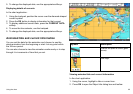
Bathymetric data
You can view detailed bathymetric contour data in the chart
application for use during shing.
Before you can display bathymetric data in the chart application, you
must have Navionics chart cards with the relevant level of detail.
When you change the CHART TYPE to the FISH option, bathymetric
data is shown on the chart (where available, based on your chart
card).
Enabling bathymetric data
In the chart application:
1. Press the PRESENTATION softkey.
2. Press the CHART LAYERS softkey.
3. Press the CHART TYPE softkey repeatedly until the FISH option
is selected.
4. Press the OK button.
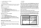
AIS objects
You can view AIS objects in the chart display to help you avoid
collisions, and identify vessels.
If you have a suitable AIS receiver or transceiver connected to your
multifunction display, you can use the AIS layer to:
• Display targets for any other AIS-equipped vessels.
• Display voyage information being broadcasted by these targets
— for example, their position, course, speed and rate of turn.
66 C-Series Widescreen user reference