


SPECIFICATIONS OF C-500
SPECIFICATIONS SUBJECT TO CHANGE WITHOUT NOTICE
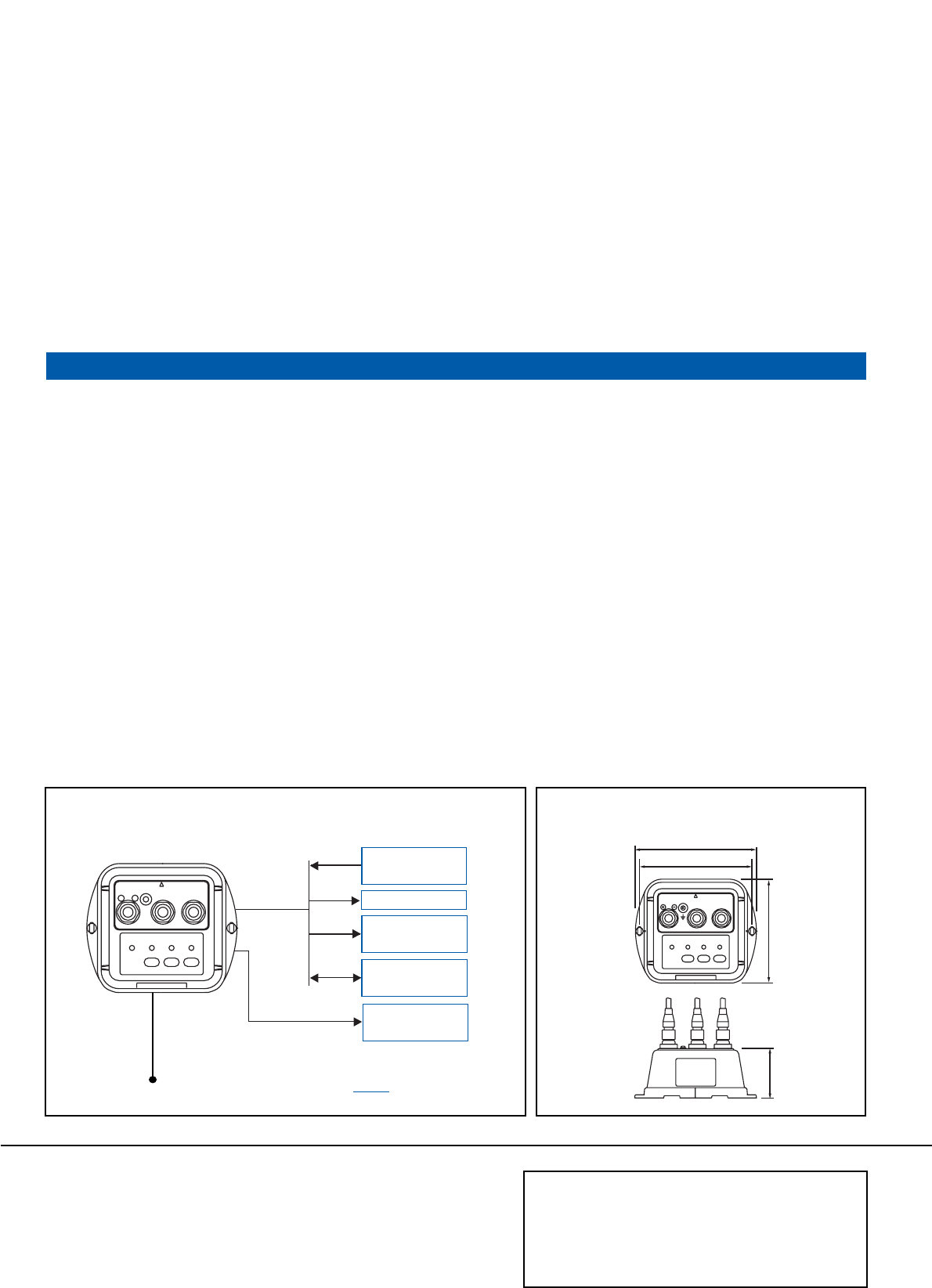
DIMENSIONS
152 6.0"
141 5.6"
130 5.1"
62 2.4"
03105T Printed in Japan
C-500
12-24 VDC
Autopilot
FURUNO
Radar/Sonar
AD-10 format
5/10 m
2/5/10 m
2 m
GPS/DGPS/
WAAS
Radar
VideoPlotter, etc.
Remote Display
RD-30
NMEA 0183
option
NMEA/IEC: 2 ports
AD-10: 1 port
0.3 kg 0.7 lb
FURUNO U.S.A., INC.
Camas, Washington, U.S.A.
Phone: +1 360-834-9300 Telefax: +1 360-834-9400
FURUNO (UK) LIMITED
Denmead, Hampshire, U.K.
Phone: +44 2392-230303 Telefax: +44 2392-230101
FURUNO FRANCE S.A.
Bordeaux-Mérignac, France
Phone: +33 5 56 13 48 00 Telefax: +33 5 56 13 48 01
FURUNO ESPANA S.A.
Madrid, Spain
Phone: +34 91-725-90-88 Telefax: +34 91-725-98-97
FURUNO DANMARK AS
Hvidovre, Denmark
Phone: +45 36 77 45 00 Telefax: +45 36 77 45 01
FURUNO NORGE A/S
Ålesund, Norway
Phone: +47 70 102950 Telefax: +47 70 127021
FURUNO SVERIGE AB
Västra Frölunda, Sweden
Phone: +46 31-7098940 Telefax: +46 31-497093
FURUNO FINLAND OY
Espoo, Finland
Phone: +358 9 4355 670 Telefax: +358 9 4355 6710
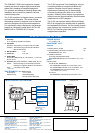
INTERCONNECTION DIAGRAM
The FURUNO C-500 is an inexpensive fluxgate
heading sensor that outputs highly accurate and
stable ship's heading to interfaced equipment.
The compact and waterproof housing allows easy
installation and is perfect for pleasure craft and
coastal fishing boats.
The C-500 consists of a fluxgate sensor, processor
and serial data interfaces. The sensor detects
the heading relative to magnetic north as induced
within the fluxgate coils by terrestrial magnetism.
For outputting to various equipment, the detected
heading is converted to serial data in IEC 61162,
NMEA 0183 or FURUNO AD-10 format.
The C-500 can provide True Heading by using its
correction facilities for magnetic deviation and
variation. Deviation (errors mainly caused by
shipboard environment) can be automatically
corrected by swinging the boat over a full 360
degrees. Variation (errors subject to geographical
location) can also be automatically corrected when
interfaced with a GPS navigator.
The C-500 can interface with the Remote Display
RD-30 for displaying the heading data in graphical
and alphanumeric formats. You can directly operate
menu settings and correction for variation from the
RD-30. This function gives speedy and
straightforward operation.
POWER SUPPLY
12 - 24 VDC, 2 W
EQUIPMENT LIST
Standard
1. Heading Sensor C-500 1 unit
2. Interface Cable (with 6p-6p connectors) 1 pc
MJ-A6SPF0007-100, 10 m
3. Installation Materials
(including power/interface cable:
MJ-A7SPF0009-020 with 7p-7p connectors, 2 m, 1 pc)
Option
Interface Cable
For IEC 61162, NMEA0183:
MJ-A7SPF0006-100 with 7p-7p connectors, 10 m
MJ-A7SPF/SRMD-100 with 7p-7p connectors, 10 m
MJ-A6SPF0003-050* with 6p connector, 5 m
(* also available in AD-10 format)
For AD-10:
MJ-A6SPF0007-100 with 6p-6p connectors, 10 m
1. Accuracy
±1.0° (excluding magnetic anomalies)
2. Correction
Deviation: Automatic by running the boat over 360°
Variation: Automatic through GP-32, GP-1850W or
Manual with RD-30
3. Roll and Pitch ±35°
4. Follow-up 6°/s max.
5. Output Rate
IEC 61162, NMEA 0183: 25, 100, 200 ms, 1 s
(selectable)
AD-10: 25 ms
6. Interface (IEC 61162-1/61162-2*, NMEA 0183, AD-10)
Output: HDG (Heading by compensating compass
heading for magnetic deviation and variation)
Input: VTG (SOG, COG), RMC
(* output only)
ENVIRONMENT (IEC 60945 testing)
Temperature: -15° to +55°C
Waterproofing: IPX5 (IEC 60529),
CFR-46 (USCG standard)