


JANUARY/FEBRUARY 2008 OCEAN NAVIGATOR 53
www.oceannavigator.com
www.oceannavigator.com
provide two SD cards on
their front panels.
SD card slots are also
provided on the Ethernet-
connected control module
for the black box system,
eliminating the need to
access to the remote central
processor unit when
switching cards.
A chartplotter can be no
better than its charts. The
NavNet 3D system is
delivered with a complete
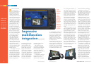
Furuno’s new
NavNet 3D
system leads
the way with
top imagery
and features
F
uruno’s new NavNet
3D system sets the
new standard for inte-
grated marine electronic
navigation systems. The
NavNet 3D chartplotter
and radar provide a level of
capability and performance
that is superior to any pre-
vious Furuno system and is
a challenge to the systems
offered by other manufac-
turers. Available with inte-
grated 8.4-inch or 12.1-
inch diagonal color LCD
screens or as a black box
system that can support up
to 10 multifunction dis-
plays, NavNet 3D will ful-
fill the electronic naviga-
tion needs of virtually any
size vessel, providing infor-
mation from system sen-
sors including WAAS,
GPS, AIS, radar, sonar,
Sirius Marine Weather,
Weatherfax, weather sta-
tion, sailing instruments,
engine instruments and IP
video cameras. The system
also interfaces with the
autopilot, a new GPS com-
pass system and the audio
program from the Sirius
Satellite receiver.
The display screen and
the controls for the most
often used functions, the
chartplotter and radar, are
the heart of any multifunc-
tion electronic navigation
system. The NavNet 3D
system is available in three
formats: integrated dis-
play/processor units with
8.4-inch diagonal, VGA
(640 x 480 pixel) color
LCD screen; a 12.1-inch
SVGA (800 x 600 pixel)
display; and a black box
version that is compatible
with virtually any multi-
sync display. The black box
system will support up to
1280 x 1024 pixel, SXGA
resolution. The LCD dis-
play units can be flush or
trunnion mounted and
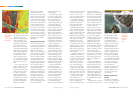
set of MapMedia’s NOAA raster,
vector and bathymetric charts
for the U.S. (including Alaska
and Hawaii) stored in its inter-
nal memory. Charts can be
updated at any time by down-
loading the latest versions from
the Furuno website
(www.NavNet.com) onto an SD
card for transfer to the plotter’s
internal memory. Satellite image
files appropriate for the planned
navigation area are also obtained
from the Furuno Web site. Since
the satellite photo files for total
U.S. coverage far exceed the sys-
tem’s memory capacity, the pic-
ture files for a defined planned
navigation area, for example the
coastline from northern New
Jersey to Cape Cod, are down-
loaded and transferred to the
internal memory. MapMedia,
S57-based charts for foreign
waters not covered by NOAA,
are downloaded in similar fash-
ion, however there will likely be
a charge for the data since virtu-
ally all countries except the U.S.
copyright and charge for their
charts.
The chart images are created
from the NOAA and other offi-
cial cartography using GIS (geo-
graphic information system)
technology. Information in GIS
form can be displayed at virtual-
ly any desired scale, with the
amount of detail information
continuously matched to the
resolution of the display system.
In the NavNet 3D system the
maximum range setting will dis-
play the entire NOAA hemi-
sphere chart. When zoomed all
the way in the chart will be seen
at a scale of 1/8th nm.
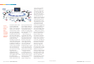
Seamless zooming
Left, the
NavNet 3D
units use track-
pads and a
rotary knob
called a
RotoKey to
select and con-
tol display ele-
ments. Lower
right, Furuno
revamped both
the NavNet
software and
its display hard-
ware. The result
is a tight inte-
grated system.
product images and screen shots courtesy Furuno
52
Impressive
multifunction
integration
By Chuck Husick
Furuno’s TimeZero technology,
a combination of software, a
high-speed processor and a pow-
erful graphics engine makes the
image flow smoothly, without
interruption and without the
need for screen re-draw. The
scrolling pad makes it easy to
move from the vessel’s present
position to anywhere in charted
U.S. and Bahamian waters and
zoom in to examine the smallest
detail. Regardless of the distance
to the location you have chosen
to examine, even thousands of
miles from your actual location,
a short stroke of the ship/3D
key in the center of the scrolling
pad will instantly restore the
normal vessel-centered chart
view. A long stroke of the com-
bination ship/3D key in the
center of the scrolling pad tog-
gles the display between 3D to
2D. In 3D display mode the
combination of the range key
and scrolling pad provides com-
plete display perspective free-
dom similar to the image man-
agement found in Google Earth.
In addition to the display of
nautical charts, tide and current
information, the NavNet 3D
system’s Satellite Photo Fusion
technology integrates satellite
images of terrain and shallow
water areas with both raster and
vector charts. The satellite pho-
tos are precisely geo-referenced
to the chart in use. The photo
image is presented so that all
land areas are completely
opaque to provide maximum
detail (photo image resolution is