


© 2002 GARMIN Ltd. or its subsidiaries
GARMIN International, Inc.
1200 East 151
st
Street, Olathe, Kansas 66062, U.S.A.
GARMIN (Europe) Ltd.
Unit 5, The Quadrangle, Abbey Park Industrial Estate, Romsey, SO51 9AQ, U.K.
GARMIN Corporation
No. 68, Jangshu 2
nd
Road, Shijr, Taipei County, Taiwan
www.garmin.com
Part Number 190-00207-00 Rev. A
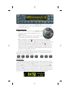
GTX 330 Mode S Transponder Features
Traffi c Information Service
The GTX 330 Mode S transponder provides a data link for Traffi c Information Service
(TIS). TIS provides a graphic display of traffi c information in the cockpit for non-TCAS
equipped aircraft. Transponder-equipped aircraft can be displayed within the coverage volume
on indicators such as a Garmin 430 or 530, within range of your position. Aircraft without an
operating transponder are invisible to TIS. Refer to 400/500 series pilot literature for details.
Mode S Data transmission
In addition to 4096 code and pressure altitude, the GTX 330 is capable of transmitting
aircraft registration number or fl ight ID, transponder capability and maximum speed range.
Audio Alerts
(Confi guration options; male/female voice or tone, and volume level.)
• “Leaving Altitude” Altitude deviation is exceeded.
• “Traffi c” TIS traffi c alert is received.
• “Traffi c Not Available” TIS service is not available or out of range.
• “Timer Expired” for countdown time.