


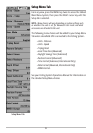

Map Datum
(Advanced)
Map Datum allows you to change the map coordinate system used by the Fishing System to
match those of a paper map. The Map Datum menu choice is only available when User Mode
is set to Advanced (see Setup Menu Tab: User Mode).
NOTE: See Setup Menu Tab: User Mode in your Fishing System Operations manual.
To change the Map Datum setting:
1. Make sure you are in Advanced User Mode, then highlight Map Datum on the
Navigation main menu.
2. Use the LEFT or RIGHT 4-WAY Cursor Control keys to change the Map Datum setting.
(Default = WGS 84)
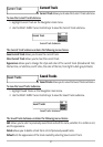
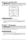
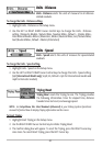
Course Projection Line
Course Projection Line allows you to display or hide an
arrow extending from the bow of the boat that projects your current course, and shows where
the boat will go if you continue on your present course.
To change the Course Project Line setting:
1. Highlight Course Projection Line on the Navigation main menu.
2. Use the LEFT or RIGHT 4-WAY Cursor Control keys to change the Course Projection Line
setting (Hidden, Visible, Default = Hidden)
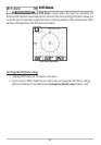
Delete All Nav Data
(Advanced)
Delete All Nav Data allows you to delete all saved Tracks and Waypoints. This menu choice
should be used with caution. The Delete All Nav Data menu choice is only available when User
Mode is set to Advanced (see Setup Menu Tab: User Mode).
NOTE: See Setup Menu Tab: User Mode in your Fishing System Operations manual.
To Delete All Navigation Data:
1. Make sure you are in Advanced User Mode, then highlight Delete All Nav Data on the
Navigation main menu.
2. Use the RIGHT 4-WAY Cursor Control key to delete all navigation data.
35