


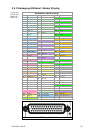

Y1-03-0212-1 Rev D 21
4) Longitude
5) E or W (East or West)
6) GPS Quality Indicator,
0 - fix not available,
1 - GPS fix,
2 - Differential GPS fix
7) Number of satellites in view, 00 - 12
8) Horizontal Dilution of precision
9) Antenna Altitude above/below mean-sea-level (geoid)
10) Units of antenna altitude, meters
11) Geoidal separation, the difference between the WGS-84 earth
ellipsoid and mean-sea-level (geoid), \-\ means mean-sea-level
below ellipsoid
12) Units of geoidal separation, meters
13) Age of differential GPS data, time in seconds since last SC104
type 1 or 9 update, null field when DGPS is not used
14) Differential reference station ID, 0000-1023
15) CRC
Used Fields: 1,2,3,4,5,6,7
1:UTC 2:Lat 3:LaInd 4:Lon
5:LoInd 6:Acc 7:Sat
GLL - Position - Latitude/Longitude
1 2 3 4 5 6 7 8
| | | | | | | |
$--GLL,llll.ll,a,yyyyy.yy,a,hhmmss.ss,A,a*hh<CR><LF>
Field Numbers:
1) Latitude
2) N or S (North or South)
3) Longitude
4) E or W (East or West)
5) Universal Time Coordinated (UTC)
6) Status A - Data Valid, V - Data Invalid
7) Mode indicator
8) CRC
Used Fields: 1,2,3,4,5,6,7
1:Lat 2:LaInd 3:Lon 4:LoInd
5:UTC 6:Valid 7:Acc
GNS - Fix Data
1 2 3 4 5 6 7 8 9 10 11 12 13
| | | | | | | | | | | | |
$--GNS,hhmmss.ss,llll.ll,a,yyyyy.yy,a,c--c,xx,x.x,x.x,x.x,x.x,x.x*hh
Field Numbers:
1) UTC
2) Latitude
3) N or S (North or South)
4) Longitude
5) E or W (East or West)
6) Mode indicator
7) Total number of satellites in use,00-99
8) HDROP
9) Antenna altitude, meters, re:mean-sea-level(geoid)
10) Goeidal separation meters
11) Age of differential data
12) Differential reference station ID
13) CRC