


30
revealing more map content (except for a few major city streets.) Load
your own high-detail custom map made with MapCreate (or a pre-made
FreedomMap from LEI), and you can zoom in to 0.02 miles with mas-
sive amounts of accurate map detail.
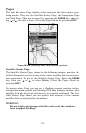
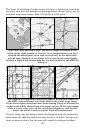
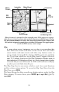
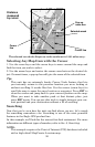
Background map vs. MapCreate map content
The background map includes low-detail maps of the whole world (con-
taining cities, major lakes, major rivers, political boundaries) and me-
dium-detail maps of the United States.
The medium-detail U.S. maps contain all incorporated cities; shaded
metropolitan areas; county boundaries; shaded public lands (such as
national forests and parks); some major city streets; Interstate, U.S.
and state highways; Interstate highway exits and exit services informa-
tion; large- and medium-sized lakes and streams; and more than 60,000
navigation aids and 10,000 wrecks and obstructions in U.S. coastal and
Great Lakes waters
MapCreate custom maps include massive amounts of information not
found in the background map. MapCreate maps contain the searchable
Points of Interest database, all the minor roads and streets, all the
landmark features (such as summits, schools, radio towers, etc.), rivers,
streams, smaller lakes, ponds and their names.
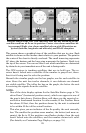
What's more important is the large scale map detail that allows your
GPS unit to show a higher level of position accuracy. For example, the
background map would show you the general outline and approximate
shape of a coastline or water body, but the higher detail in MapCreate
shows the shoreline completely and accurately (finer detail). Many
smaller islands would not be included in the background map, but are,
of course, in MapCreate.
NOTE:
Available through LEI Extras (look inside back cover for accessory
ordering information), FreedomMaps are pre-made maps that con-
tain all of the same information available in a custom MapCreate
map, without any of the work of preparation.