


SP - 3 E3503S02C
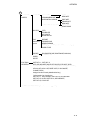
Guard Alarm (G(IN), G(OUT)), Echo Stretch (ES),
Range and Bearing to Cursor or Cursor Position,
Echo Trailing (TRAIL), Trailing Time,
Data Box (Position, COG, SOG, STW etc. selectable on menu)
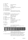
4.5. Input Data IEC 61162-1 (NMEA 0183 Ver1.5/2.0)
Own ship’s position: GGA>RMC>RMA>GLL
Ship’s speed: RMC>RMA>VTG>VHW
Bearing (True): HDT>HDG
*1
>HDM
*1
>VHW
Bearing (Magnetic): HDM>HDG
*1
>HDT
*1
>VHW
Course: RMC>RMA>VTG
Waypoint (Range, bearing): RMB>WPL>BWR>BWC
Water depth: DPT>DBT>DBS>DBK
Wind: MWV>VWT>VWR
Water Temperature: MTW
Time: ZDA
*1
: calculated by magnetic deviation
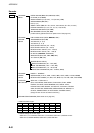
4.6. Output Data
Alarm signal 12 VDC, 100 mA or less
NMEA 0183 Ver1.5 GGA, GLL, RMA, RMC, GTD, VTG, ZDA (GPS data required)
RMB, WPL, BWC or BWR, APB, AAM, BOD, XTE, VHW, MTW,
DPT or DBT, DBS (ETR required),
TLL (L/L, Heading data required), TTM (ARPA required)
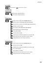
5. PLOTTER FUNCTION
5.1. Projection Mercator
5.2. Usable Area 85 latitude or below
5.3. Effective Area 211.2 x 158.4 mm
5.4. Display pixels 640 x 480 dots
5.5. Position Indication Latitude/longitude, Loran C LOP or DECCA LOP
5.6. Effective Projection Area 0.125 nm to 1,024 nm (at equatorial area)
5.7. Track Display Plot interval: by time (1 sec. to 99 min. 59 sec.) or
by distance (0 to 99.9 nm)
5.8. Colors Red, yellow, green purple, light-blue, blue, white
5.9. Memory Capacity Track/mark: 8000 points, Waypoint: 999 points
5.10. Storage Capacity Simple route: 200 routes with 35 waypoints each
5.11. MOB 1 point
5.12. Quick Routes 1 course with 35 waypoints max.
5.13. Electronic Chart FURUNO chart card or NAVIONICS chart card available