


190-00228-08 GPS 16x Technical Specifications Rev. B
Page 16
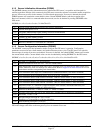
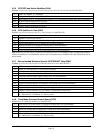
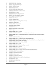
4.2.5 GPS DOP and Active Satellites (GSA)
$GPGSA,<1>,<2>,<3>,<3>,<3>,<3>,<3>,<3>,<3>,<3>,<3>,<3>,<3>,<3>,<4>,<5>,<6>*hh<CR><LF>
<1> Mode, M = Manual, A = Automatic
<2> Fix type, 1 = Not available, 2 = 2D, 3 = 3D
<3> PRN number, 01 to 32, of satellite used in solution, up to 12 transmitted (leading zeros will be transmitted)
<4> Position dilution of precision, 0.5 to 99.9
<5> Horizontal dilution of precision, 0.5 to 99.9
<6> Vertical dilution of precision, 0.5 to 99.9
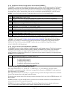
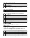
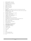
4.2.6 GPS Satellites in View (GSV)
$GPGSV,<1>,<2>,<3>,<4>,<5>,<6>,<7>,...<4>,<5>,<6>,<7>*hh<CR><LF>
<1> Total number of GSV sentences to be transmitted
<2> Number of current GSV sentence
<3> Total number of satellites in view, 00 to 12 (leading zeros will be transmitted)
<4> Satellite PRN number, 01 to 32 (leading zeros will be transmitted)
<5> Satellite elevation, 00 to 90 degrees (leading zeros will be transmitted)
<6> Satellite azimuth, 000 to 359 degrees, true (leading zeros will be transmitted)
<7> Signal to noise ratio (C/No) 00 to 99 dB (leading zeros will be transmitted)
Note: Items <4>,<5>,<6>, and <7> repeat for each satellite in view to a maximum of four (4) satellites per sentence.
Additional satellites in view information must be sent in subsequent bursts of NMEA 0183 data. These fields will be
null if unused.
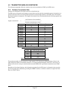
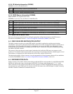
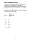
4.2.7 Recommended Minimum Specific GPS/TRANSIT Data (RMC)
$GPRMC,<1>,<2>,<3>,<4>,<5>,<6>,<7>,<8>,<9>,<10>,<11>,<12>*hh<CR><LF>
<1> UTC time of position fix, hhmmss format
<2> Status, A = Valid position, V = NAV receiver warning
<3> Latitude, ddmm.mmmm format (leading zeros will be transmitted)
<4> Latitude hemisphere, N or S
<5> Longitude, dddmm.mmmm format (leading zeros will be transmitted)
<6> Longitude hemisphere, E or W
<7> Speed over ground, 000.0 to 999.9 knots (leading zeros will be transmitted)
<8> Course over ground, 000.0 to 359.9 degrees, true (leading zeros will be transmitted)
<9> UTC date of position fix, ddmmyy format
<10> Magnetic variation, 000.0 to 180.0 degrees (leading zeros will be transmitted)
<11> Magnetic variation direction, E or W (westerly variation adds to true course)
<12> Mode indicator (only output if NMEA 0183 version 2.30 active), A = Autonomous,
D = Differential, E = Estimated, N = Data not valid
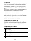
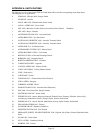
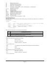
4.2.8 Track Made Good and Ground Speed (VTG)
$GPVTG,<1>,T,<2>,M,<3>,N,<4>,K,<5>*hh<CR><LF>
<1> True course over ground, 000 to 359.9 degrees (leading zeros will be transmitted)
<2> Magnetic course over ground, 000 to 359.9 degrees (leading zeros will be transmitted)
<3> Speed over ground, 000.0 to 999.9 knots (leading zeros will be transmitted)
<4> Speed over ground, 0000.0 to 1851.8 kilometers per hour (leading zeros will be transmitted)
<5> Mode indicator (only output if NMEA 0183 version 2.30 active), A = Autonomous,
D = Differential, E = Estimated, N = Data not valid