


26 GDL 30/30A Owner’s Manual
Product Safety and Regulatory Information
The GPS system is operated by the United States government, which is solely
responsible for its accuracy and maintenance. The system is subject to changes
which could affect the accuracy and performance of all GPS equipment. Although
the Garmin GDL 30/30A is a precision electronic NAVigation AID (NAVAID),
any NAVAID can be misused or misinterpreted and, therefore, become unsafe.
The electronic chart is an aid to navigation and is designed to facilitate the use of
authorized government charts, not replace them. Only ofcial government charts
and notices to mariners contain all information needed for safe navigation. As
always, the user is responsible for prudent use of this information.
Use the GDL 30/30A at your own risk. To reduce the risk of unsafe operation,
carefully review and understand all aspects of this Owner’s Manual. If necessary,
thoroughly practice operation using the simulator mode prior to actual use.
When in actual use, carefully compare indications from the unit to all available
navigation sources, including the information from other NAVAIDs, visual
sightings, and charts. For safety, always resolve any discrepancies before
continuing navigation.
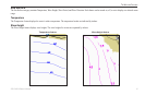
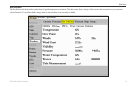
Weather and Sea Surface information
The GDL 30/30A receives XM Weather Radio data and shows it on your
chartplotter. The weather data for each feature comes from reputable weather
data centers such as the National Weather Service and the Hydrometerological
Prediction Center. (See the XM WX Satellite Weather Web site at http://weather.
xmradio.com/weather for more information.) Any weather feature can change in
appearance or interpretation if the source that provides the information changes.
XM Weather Radio data is broadcast at set rates (see page 24 for all weather-
related broadcast rates). For example, NEXRAD Radar data is broadcast at ve
minute intervals. When the marine network is turned on or when a new feature
is selected, the GDL 30/30A has to receive new data before it can be displayed.
For this reason you may experience a delay before weather data or a new feature
appears on the map.
Caution
IT IS THE USER’S RESPONSIBILITY TO USE THIS PRODUCT
PRUDENTLY. THIS PRODUCT IS INTENDED TO BE USED ONLY AS A
NAVIGATIONAL AID AND MUST NOT BE USED FOR ANY PURPOSE
REQUIRING PRECISE MEASUREMENT OF DIRECTION, DISTANCE,
LOCATION, OR TOPOGRAPHY.
appendIX