


2-3
2.3 Turning the Radar On/Off
Press the [POWER] key to turn the radar on.
To turn the radar off, press the [POWER] key
together with the [STBY/TX] key.
When the radar is turned on, the control panel
lights and a timer displays the time remaining
for warm up of the magnetron (the device which
produces radar pulses), counting down from
1:30 to 0:01 (2:00 to 0:01 for FR-7252).
2.4 Transmitting
After the power is turned on and the magnetron
has warmed up, STBY (Stand-By) appears at
the screen center. This means the radar is now
fully operational.
Press the [STBY TX] key to transmit.
When transmitting, any echoes from targets
appear on the display. This radar displays ech-
oes in eight tones of green according to echo
strength.
2.5 Stand-by
When you won’t be using the radar for an ex-
tended period, but you want to keep it in a state
of readiness, place it in stand-by by pressing
the [STBY/TX] key. The display shows
“STBY,” (default setting) navigation data, or
goes into the economy mode. (You can select
stand-by condition on the menu. More on menu
operation later.)
Economy mode
The CRT can be set to automatically turn itself
off when in stand-by, to reduce power consump-
tion. This feature is called the “economy mode”.
When the economy mode is on, the
“ECONOMY” indication under the [STBY/TX]
key lights.
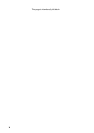
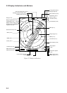
Navigation data display during
stand-by
If a navigation aid inputs navigation data to this
radar, navigation data can be displayed during
stand-by. You can turn the navigation data dis-
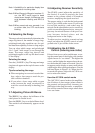
play on/off through the menu. Figure 2-3 shows
a typical navigation data display during stand-
by.
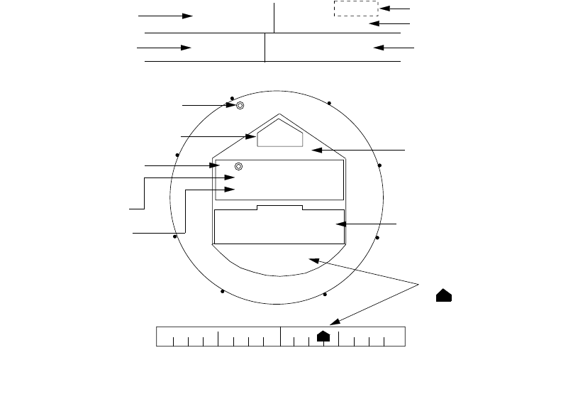
Figure 2-3 Typical navigation data display
during stand-by
Bearing to TO
Waypoint
N
SPEED
TRIP
DEPTH TEMPERATURE
10.5
kt
125
m
ST-BY
000.3 nm
+17.3
°C
HDG
092.5°
WPT TTG 01:08
BRG
RNG
45.0° M
12.0NM
OWN SHIP
LAT 30°00.00N
LON 135°00.00E
TD 36378.1
59096.4
XTE
R 0.3NM
E
S
W
L
R
XTE
XTE
Time-to-go to Stand-by
Trip distance since power on
Speed
Depth
TO Waypoint bearing
Course
Heading
Time-to-go to
TO Waypoint
Range to TO Waypoint
Ship's position in
latitude and longitude
and Loran TDs
Cross Track Error
" " shows direction
and amount of error.
1.0
0.5
0.5
1.0
Temperature
*
: "M" is not displayed on N-type radar.
CRS 180.0°M
*
*