


7. CUSTOMIZING YOUR UNIT
7-25
7.7.2 FURUNO BB GPS receiver setup
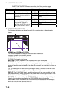
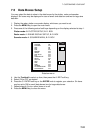
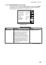
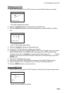
The GPS SETUP menu sets up a FURUNO BB GPS receiver. Press the MENU
key followed by the E: SYSTEM CONFIGURATION, B: NAV OPTION and B:
GPS SENSOR SETTINGS soft keys to display this menu.
GPS
SETUP
GEODETIC DATUM WGS-84
POSITION SMOOTHING 000 second (s)
SPD/CSE SMOOTHING 005 second (s)
LATITUDE OFFSET 0.000’N
LONGITUDE OFFSET 0.000’E
DISABLE SATELLITE - - - - - -
LATITUDE 45
°
35.000’N
LONGITUDE 125
°
00.000’W
ANTENNA HEIGHT 005 m
GPS FIX MODE 2D/3D
COLD START NO
RETURNE
GPS
STATUS
B
EDITA
WAAS
SET UP
C
GPS setup menu
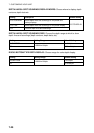
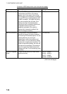
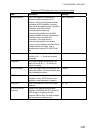
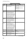
Contents of GPS setup menu
Item Description Settings
Geodetic Datum
Geodetic datum is a reference for geodetic
survey measurements consisting of fixed
latitude, longitude and azimuth values
associated with a defined station of
reference. You must have the correct
geodetic datum selected in your plotter so
that it will reference the correct point on
the chart for a given latitude and longitude.
Although WGS-84 is now the world
standard, other categories of charts still
exist. Refer to Appendix for a full list of
geodetic datum.
See Appendix for full list.
(Con’t on next page)