


3. INITIAL SETTINGS
11
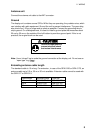
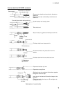
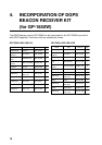
Input/Output data sentences
Port Format Data Remarks
NMEA
Input
NMEA-0183
Ver. 2.0
Ver. 1.5
IEC1162
TLL*1, MTW, WPL*1, DBT/DPT
WPL: GP only
NMEA Ver 1.5: DBT
NMEA Ver 2.0: DPT
Output
AAM, APB, BOD, BWC/BWR,
GGA, GLL, RMA, RMB, RMC,
VTG, WPL, XTE, ZDA, MTW,
GTD*2
GREAT CIRCLE: BWC
RHUMB LINE: BWR
DGPS
Input
NMEA-0183
Ver. 2.0
Ver. 1.5
RS232C
RTCM104
TLL*1, MTW, WPL*1, DBT/DPT
ylnoPG:LPW
TBD:5.1reVAEMN
TPD:0.2reVAEMN
Output
AAM, APB, BOD, BWC/BWR,
GGA, GLL, RMA, RMB, RMC,
VTG, WPL, XTE, ZDA, MTW,
GTD*2
GREAT CIRCLE: BWC
RHUMB LINE: BWR
*1: Cannot be input consecutively.
*2: Output automatically when LC or LA is selected.
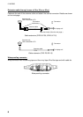
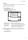
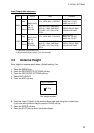
3.3 Antenna Height
Enter height of antenna above water. (Default setting: 5 m)
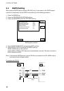
1. Press the [MENU] key.
2. Press the GPS/DGPS/TD OPTIONS soft key.
3. Press the GPS SETUP OPTIONS soft key.
4. Select ANT. HEIGHT.
5. Press the EDIT soft key.
ANT. HEIGHT
0 0 5 m
Ant. height window
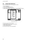
6. Enter the height (3 digits) of the antenna above sea level using the numeric keys.
If you enter wrong antenna height, press the CLEAR soft key.
7. Press the ENTER soft key.
8. Press the [PLOT] key to return the plotter display.