


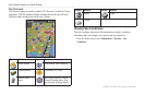

XM WX Satellite Weather and Cellular Weather
10 GPSMAP 400/500 Series Weather Supplement
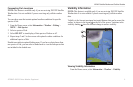
Viewing Forecast Visibility Information for Another Time
Period
1. From the Home screen, select > > .
2. Complete an action:
• To view the visibility forecast for the next 12 hours, select right on the
, and to view forecasts up to 48 hours, in 12-hour increments,
select right on the again.
• To view the visibility forecast for the previous 12 hours, select left
on the and to view previous forecasts, up to 48 hours ago, in
12-hour increments, select left on the again.
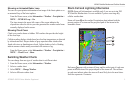
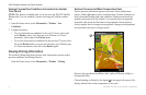
Viewing Buoy Reports
Report readings are taken from buoys and coastal observation stations. These
readings are used to determine air temperature, dew point, water temperature,
tide, wave height and period, wind direction and speed, visibility, and
barometric pressure.
1. From the Home screen, select > > .
2. Select > .
3. Select > .
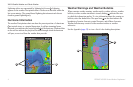
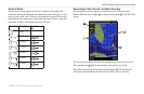
Viewing Local Weather Information near a Buoy
You can select an area near a buoy to view forecast information.
1. From the Home screen, select > > .
2. Select > .
3. Complete an action using the :
• Select a location on the chart.
• Pan to a new location, and select the location on the chart.
4. Select .
5. Complete an action:
• To view present weather conditions from a local weather service,
select
• To view a local weather forecast, select .
• To view surface wind and barometric pressure information, select
.
• To view wind and wave information, select .
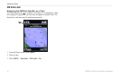
Creating a Waypoint on the Forecast Chart
1. From the Home screen, select > > .
2. Select > .
3. Complete an action using the :
• Select a location on the chart.
• Pan to a new location, and select the location on the chart.
4. Select .