


68
T
o change the Map Borders setting:
1. Highlight Map Borders on the Chart main menu.
2. Use the LEFT or RIGHT 4-WAY Cursor Control keys to change the Map Borders
setting. (Hidden, MMC/SD Only, All Visible, Default = Hidden)
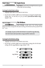
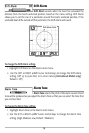
Lat/Lon Grid
Lat/Lon Grid allows you to display or hide a grid
showing latitude and longitude lines.
To change the Lat/Lon Grid setting:
1. Highlight Lat/Lon Grid on the Chart main menu.
2. Use the LEFT or RIGHT 4-WAY Cursor Control keys to change the Lat/Lon Grid
setting. (Hidden, Visible, Default = Hidden)
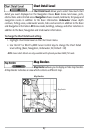
Set Simulation Position
(Advanced)
Set Simulation Position allows you to set the position of the boat used in the Simulator.
The Set Simulation Position menu choice is only available when User Mode is set to
Advanced (see Setup Menu Tab: User Mode).
To set the Simulation Position:
1. Activate the cursor and move it to the coordinates from where you want the
simulation to start.
NOTE: The cursor must be active in order for this procedure to work.
2. Make sure you are in Advanced User Mode, then highlight Set Simulation
Position on the Chart main menu.
3. Use the RIGHT 4-WAY Cursor Control key to change the Simulation Position
setting. A confirmation dialog box will appear to allow you to change your
mind, or to confirm your choice. If the cursor was not active before you
began this procedure, you will see an error message. Exit the menu, set the
cursor, then try again.