


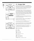
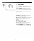
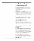
The
Basics of
GPS
GPS,
or Global
Positioning System,
is
a
satellite
navigation
system
designed
to
provide worldwide
positioning and time
information
with
all
weather
capability.
quick
response time
and accuracy
to
within
several
yards.
GPS
is maintained
by the
United States
Department
of
Defense
24 hours
a day.
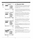
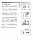
GPS
is a system
of 24
satellites orbiting
at an altitude
very high
above
the earth.
Because
of the
great
altitude, the
satellites'
signals
are
not
interfered
with by the terrain
or
geography,
and
the high
frequency of
the signals
(
l-500
MHz) results
in
practically no
interence
from shipboard
engines
or other electronic
systems.
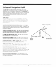
GPS uses
the
principle
of
ranging to
give
you your
position. This is
done
by measuring
the distance
fiom
your
position
to the
position
of
at
least three
satellites.
The distance
to a satellite
is calculated
by
measuring
how long
it takes
radio si-unals to arrive
fiom
the known
position of each of
the
respective satellites
in their orbits.
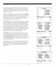
The satellites
and the Star
Pilot must be
precisely
tirned
to
generate
the exact
same
radio signal at
the exact same
time in order
to
measure
the time
and distance
calculations
with
a
high degree of
accuracy.
This is accomplished
by the
use of atomic
clocks on all
the satellites,
and
by comparing
what
part
of the
radio signal code
is
received at the
exact same time
from all
the satellites.
To
complete
its
calculations
for
your
position,
the
Star
Pilot looks up
in its
data
base the
known
position
of each of
the satellites
at that
exact time.
Because
the GPS
satellites are
in such a high
orbit, their
positions
at any
given
time are
quite predictable. Now. all the Star
Pilot
needs to do
is calculate all this
tor three or
four satellites
every
few seconds, and
you
have continuous
position
updatin-e!
GPS satellites
are constantly
monitored by Department
of
Defense
ground
stations. Satellite
clocks
and exact
positioning information
is
computed and
any
variations are
noted or comected
as necessary.
and
transmitted
to the appropriate
satellites. Other
possible sources of
errors, such as
atmospheric
drag and
geometric
position measurement
discrepancies,
are
eliminated
by the sophisticated,
mathematical
programming within the Star
Pilot GPS
system.
20