


See the 'Using the Chart' chapter of the Reference Manual.
D8841_2
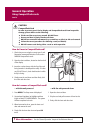
What can I see?
Displaying additional information (continued)
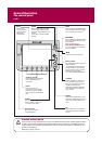
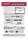
Card 8
CHART LAYERS...
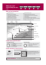
PRESENTATION…
Enable soft key
AERIAL
O
VERLA
Y
OFF
O
N
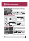
If you are using a suitable chart card, you can display a panoramic
photo(s) of many ports and marinas. The availability of photos is
indicated by the camera symbol on the chart. This symbol is placed
where the photo was taken and the angle of the shot is indicated
by the camera symbol.
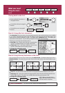
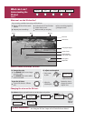
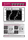
How do I display pilot book information?
This will enable you to view detailed information normally contained in an almanac..
OK
Highlight and select the pilot
book option
Select
appropriate
port symbol
OBJECT INFO
RAINBOW MARINA
Photos
Position
29
0
58'.147N
093
0
52'.215W
Boo
k
5, C
h
p
5
Pi
lo
t B
ook
OBJECT INFO
RAINBOW MARINA
Photos
Pilot Book
Position
29
0
58'.147N
093
0
52'.215W
Highlight required
book/chapter
Selected book/chapter
displayed
VIEW PILOT BOOK
B
ook 5, Ch
p
5
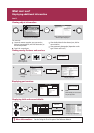
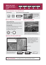
How do I display aerial photo overlay?
The aerial photo overlay feature will help you to interpret your
environment and its features. If you are using a suitable chart
card, this overlay will appear by default on 3D chart windows
and can be applied to individual 2D chart windows when
required.
3D - Aerial photo overlay can be switched off via
the 3D Chart Setup Menu.
2D - Adjust the opaqueness level using the rotary control.
Specify land only or land/sea overlay via the cartographic menu.
Applying aerial photo overlay to a 2D chart:
1.
2.
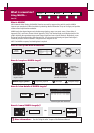
How do I display a panoramic photo?
Select required
camera symbol
VIEW PHOTO
OK
?
More information...