


5. CUSTOMIZING YOUR UNIT
5-25
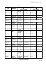
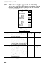
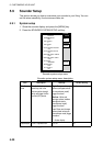
Contents of GPS sensor setup menu (con’t from previous page)
Item Description Settings Default Setting
Spd/Cse
Smoothing
During position fixing, ship’s velocity (speed and course)
is directly measured by receiving GPS satellite signals.
The raw velocity data may vary too much depending on
receiving conditions and other factors. You can reduce
this variance by increasing the smoothing. Like with
latitude and longitude smoothing, the higher the speed
and course smoothing the higher the smoothing setting,
the more the raw data will be averaged. If this setting is
high, the response to speed and course changes will
slow. For no smoothing, enter all zeros.
0-999 sec
5 sec
GPS Speed
Averaging
Calculation of ETA is based on average ship’s speed
over a given period. If the period is too long or too short,
calculation error will result. Change this setting if
calculation error occurs. The default setting is suitable for
most conditions.
0-999 sec 60 sec
Latitude,
Longitude
Offset
Offsets latitude position to further refine position
accuracy. Use the N<− −>S soft key to switch
coordinate.
0.001’S – 9.999’N
0.001’E – 9.999’W
0.0’ (no offset)
Disable
Satellite
Every GPS satellite is broadcasting abnormal satellite
number(s) in its Almanac, which contains general orbital
data about all GPS satellites, including those which are
malfunctioning. Using this information, the GPS receiver
automatically eliminates any malfunctioning satellite from
the GPS satellite schedule. However, the Almanac
sometimes may not contain this information. If you hear
about a malfunctioning satellite from another source, you
can disable it manually. Enter satellite number (two digits,
max. 3 satellites) with the trackball and [ENTER] knob
and press the ENTER soft key.
None
Latitude
Sets initial latitude position after cold start. Use the
N< − −>S soft key to switch coordinate.
—
45°35.000’N
Longitude
Sets initial longitude position after cold start. Use the
W< − −>E soft key to switch coordinate.
—
125°00.000’W
Antenna
Height
Enters the height of the GPS antenna unit above sea
surface. For further details refer to the installation
manual.
0-99 m 5 m
GPS Fix
Mode
Chooses position fixing method:
2D (
three satellites in
view), 2D/3D (three or four satellites in view whichever is
greater)
.
2D, 2D/3D 2D/3D
Cold Start Clears the Almanac to receive the latest Almanac. No, Yes No
GPS STATUS
(soft key)
Displays GPS satellite status display. Requires GPS Receiver GP-310/320B or GPS navigator outputting
the data sentence GSA or GSV. For further details see the chapter on Maintenance.