


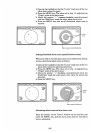
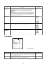
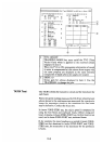

9-14
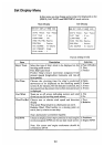
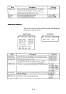
Item Description Selection
Current
Reference
Choose either data from nav sensor or water reference to calculate
speed/direction of water current and wind when ground tracking is
not attainable.
Yes: Data from nav sensor is used when ground tracking is not
attainable.
No: Speed/direction of current and wind is measured with respect to
water mass in the water tracking depth, when ground tracking is not
attainable. When a GPS navigator is connected to the DS-30, it is
recommended that “Yes” is selected.
1. Yes
2. No
Data Interval Choose the data output interval to the external data recorder (option). 1. 15 sec
2. 30 sec
3. 1 min
4. 2 min
5. 5 min
6. 10 min
7. 15 min
8. 30 min
HED. INTVL Choose heading data interval for calculating rate of turn. 1. 0sec
2. 10sec
3. 30sec
4. 60 sec
5. 90 sec
6. 120 sec
ROT
AVERAGE
Set averaging time for “rate of turn” data. 1. 0sec
2. 10sec
3. 30sec
4. 60 sec
5. 90 sec
6. 120 sec
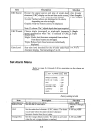
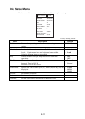
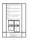
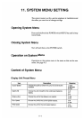
Offset Data Menu
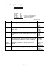
PARAMETERS
TRIM : +0.0
°
HEEL : +0.0°
XDCR OFFSET : +0.0°
COMPASS CORR : +0.0°
R. O. T. ZERO : +0.0°/min
GND TRL SPD : +0.0°
WTR TRK SPD : +0.0°
UKC OFFSET : +0.0°
SPPED DIFF : EXECUTE?
Factory setting in bold
END
Item Description Selection
Trim Set ship’s trim, that is, the relationship of the draft at bow and stern.
Use “+” polarity when the ship is down by the stern and “-” polarity
when it is down by the head.
-12.5 to +12.5°
0.0°
Heel Set ship’s heel, that is, lateral inclination. Use “+” polarity for
starboard up and “-” polarity for starboard down.
-12.5 to +12.5°
0.0°