


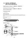
15-2
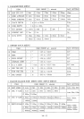
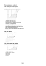
Data sentences (input)
DBT – Depth below transducer
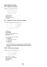
$--DBT,x.x,f,x.x,M,x.x,F*hh<CR><LF>
| | | | | | |
| | | | | | +--------- 4
| | | | +--+----------- 3
| | +--+----------------- 2
+--+----------------------- 1
1. Water depth, feet
2. Water depth, m
3. Water depth, fathoms
4. Checksum
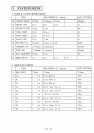
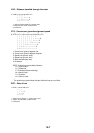
GLL – Geographic position, latitude and longitude
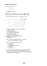
$--GLL,llll.lll,a,yyyyy.yyy,a,hhmmss.ss,A,a*hh<CR><LF>
| | | | | | | |
| | | | | | | +------- 6
| | | | | | +--------- 5
| | | | | +----------- 4
| | | | +---------------- 3
| | +------+----------------------- 2
+---+----------------------------------- 1
1. Latitude, N/S
2. Longitude, E/W
3. UTC of position
4. Status: A=data valid, V=data invalid
5. Mode indicator(see note)
6. Checksum
NOTE Positioning system Mode indicator:
A = Autonomous
D = Differential
E = Estimated (dead reckoning)
M = Manual input
S = Simulator
N = Data not valid
The Mode indicator field supplements the Status field. The Status field shall be
set to V=invalid for all values of Operating Mode except for A=Autonomous and
D=Differential. The positioning system Mode indicator and Status field shall not
be null fields.
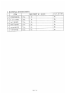
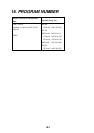
MWD – Wind direction and speed
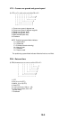
$--MWD,x.x,T,x.x,M,x.x,N,x.x,M*hh<CR><LF>
| | | | | | | | |
| | | | | | | | +--- 5
| | | | | | +--+----- 4
| | | | +--+----------- 3
| | +--+----------------- 2
+--+----------------------- 1
1. Wind direction, 0 to 359 true
2. Wind direction, 0 to 359 Magnetic
3. Wind speed, knots
4. Wind speed, m/s
5. Checksum