


12-1
12. ROUTES
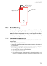
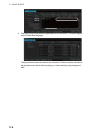
12.1 Route Planning Overview
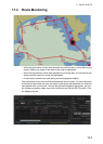
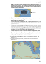
A route plan defines the navigation plan from starting point to the final destination. The
plan includes:
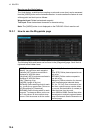
Using the above-mentioned data, the system calculates speed, course and length for
each leg, ETAs for each waypoint, fuel consumption and WOP. It also calculates safe
water areas based on user-defined channel limits. The calculated data is displayed in
tabular form, which can be printed as a documented route plan and also stored in a
file for later use.
Note 1: If you have small scale chart(s) on display having the whole eastern/western
(0-180°E/0-180°W) hemisphere and a part of the other hemisphere on display, there
is a limitation to display a route. To avoid this, set chart center so that the whole east-
ern/western hemisphere is not on the display. A maximum of five routes can be edited
simultaneously.
Note 2: If a planned route's Safety Margin or Channel Limit contains excessive land
masses, the chart radar may freeze during a route check. If this occurs, reset the chart
radar, then adjust the Channel Limit and Safety Margin settings in the Route Plan di-
alog box's Waypoints so that land mass is not included in the route.
A route plan defines the navigation plan from starting point to the final destination. The
plan includes:
• Route name
• Name, latitude and longitude of each waypoint
• Radius of turn circle at each waypoint
• Safe channel limits
• Chart alarm calculation based on channel limits against chart database and user chart
danger
• UKC calculation
• Deadband width, nominal deadband width used for the chart operating modes with
moderate accuracy and economical sailing behavior
• Minimum and maximum speed for each leg
• The navigation method (rhumb line, great circle)
• Fuel saving
• ETD for the first waypoint
• ETA for the last waypoint
• Ship and environmental condition affecting the ship speed calculation
• Name of the user chart to use during route navigation together with the planned route
• Name of the Notes to use during route navigation together with this planned route, in
the user chart dialog box
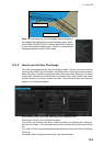
Main functions of route planning are:
• Define waypoints
• Define turnings for each waypoint
• Define channel limits for each leg (a leg is the line connected between two waypoints).
The channel limits are used to detect chart alerts when you are planning or monitoring
your route.
• Define the speed for each leg
• Calculation for ETD and ETA
• Calculation for most economical sailing