


16. NAVIGATION SENSORS
16-12
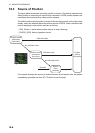
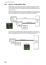
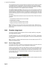
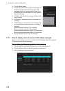
The [Comparisons] column shows the sensors compared and the integrity evaluation
of compared sensors in parentheses. Using the illustration above as an example,
SOG/COG data fed from GP0002 is compared with the sensors GP0001 and VD0001.
The integrity evaluation for the compared sensors is [Passed].
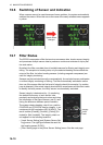
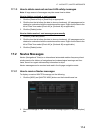
To unselect a sensor manually, select the sensor from the drop-down list at the bot-
tom left corner of the page, click the [Unselect] button then click the [Save] button. [Un-
selected] appears in the [Status] column. To reselect an unselected sensor, select the
sensor from the drop-down list, click the [Select] button. [Selected] appears in the [Sta-
tus] column
The [Reset Filter] button functions to recover from sensor failure. When the button is
operated:
• Automatically excluded sensors are re-included.
• All data history is erased.
• Output values are re-estimated using new data.
• Integrity monitoring is restarted using new data.
Note: The filter can also be reset from the context-sensitive menu. Right-click any-
where in the Sensor information box to show the context-sensitive menu then select
[Filter Reset].
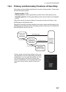
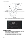
16.8 Position Alignment
The position alignment feature functions to fine tune ship's position by using radar
echo target and chart material.
If position alignment is in use, the Alert 640 "Chart Align: Over 30 Min." is generated
every 30 minutes to remind the user to align position. The alert is automatically erased
in 10 seconds.
Note: This feature is effective with the chart radar unit whose data source for FILT is
assigned the highest priority.
16.8.1 How to align position
If the radar echo targets' symbols are not positioned correctly on the chart, there is ei-
ther position error or gyro error or some combination of these errors.
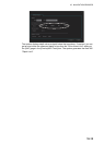
Position may be aligned on the chart radar display by moving own ship position or by
moving radar target position. To align position, get into the Voyage navigation mode,
click the [Offset] button at the top-right position on the screen, put the cursor on the
correct position then click. The amount of offset, in bearing and range, appears to the
right the [Offset] button.
The latitude and longitude position indication is shown in yellow characters when the
position align feature is active.