


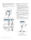

7GPSMAP 4000/5000 Series Installation Instructions
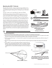
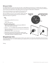
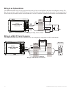
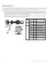
Wiring the GPS 17 Antenna
The GPS 17 antenna must be wired to the included 19-pin NMEA 0183 cable as well as to the boat’s power supply. Refer to the diagram below
when wiring the GPS 17 to the 19-pin NMEA 0183 cable. Use 22 AWG shielded wiring for extended runs of wire to the NMEA 0183 cable or
GPS 17 cable. Solder all connections and seal them with heat shrink tubing.
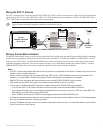
If you are using more than one Garmin chartplotter over a Garmin Marine Network, only wire one chartplotter to a GPS 17. The GPS
signal is shared between multiple chartplotters connected to a Garmin Marine Network.
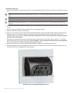
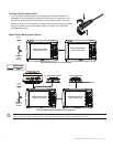
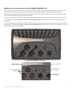
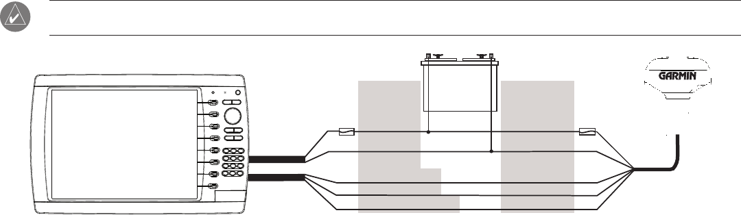
Wiring the GPSMAP 4000/5000 Unit and the GPS 17
+
-
>
>
>
>
BATTERY
10-35 VDC
WIRE
COLOR
WIRE
COLOR
RED (POWER)
BLACK (GND)
ORANGE (ACC. ON)
GREEN (DATA OUT)
GREEN/WHITE (DATA IN)
RED (POWER)
BLACK (GND)
YELLOW (ON)
BLUE (DATA IN)
WHITE (DATA OUT)
FUSE
7.5A - 42V
FUSE
1 A
Garmin
GPSMAP 4000/5000
Series Unit
GPS 17
GPS/WAAS
Sensor
POWER
CABLE
NMEA 0183
CABLE
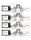
Wiring a Garmin Marine Network
The optional Garmin Marine Network is a plug-and-play system that allows for high-speed data transfer between multiple Garmin chartplotters
and other network compatible Garmin devices such as a Garmin sonar unit (GSD 22), a Garmin radar (GMR 18 or GMR 404/406), or an XM
Weather receiver (GDL30/30A). The GPSMAP 4000/5000 units have three network ports that can be used to connect other Garmin network
compatible chartplotters and devices. If the network requires more ports, use a Garmin Marine Network port extender (GMS 10), or another
GPSMAP 4000/5000. Data from each connected component is shared by all the connected Garmin chartplotters.
Notes:
• The GPS 17 antenna and standard NMEA devices must all be wired to one chartplotter on the network. The data is then shared over the
network to other connected chartplotters.
• Connectnetworkcomponents,suchasaGarminGMRradar,GSDsounder,orGDLXMWeatherreceivertoanychartplotteronthe
network or to an optional GMS 10 Network Port Expander. Data is shared between all chartplotters on the network.
• BlueChart
®
g2 Vision cartography data is shared between any connected GPSMAP 4000/5000 series chartplotter.
• Video input(s) from the Marine Video cable is only viewable on the chartplotter to which it is connected.
• You can connect a GPSMAP 4000/5000 chartplotter to a Marine Network with a GPSMAP 3000 series chartplotter:
They will share GPS 17 GPS position information as well as information to and from standard NMEA 0183 devices.
TheywillshareinformationfromconnectednetworkcompatibleGarmindevicessuchasasonarunit(GSD22),aradar(GMR18or
GMR404/406),oranXMWeatherreceiver(GDL30/30A).
Garmin GPSMAP 3000 series units CANNOT share cartography data with the GPSMAP 4000/5000 units.
• All network components must be connected to the boat’s power source according to their installation instructions. The following diagrams
show only the network connections, not power connections.
• Currently,XMWeatherandaudioserviceisonlyavailableinNorthAmerica.Becauseofthis,aconnectedXMWeatherreceiver(GDL30/
30A) will only function in North America.
•
•
•