


22
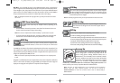
Combo View (with optional-purchase GPS receiver)
Combo View - This view is only available if you have purchased and connected a GPS Receiver, and
is displayed as a split screen, with Chart View on the left and Sonar View on the right side of the
screen. The width of the sonar window can be changed.
View Orientation (with optional-purchase GPS receiver)
Both Chart and Combo views (available when you have purchased and connected a GPS Receiver)
allow you to choose the orientation of the view. When North-Up orientation is selected, True
North is shown at the top of the display. In other words, objects located to the north of the boat
are drawn above the boat. When Course-Up orientation is selected, the direction of motion of the
boat is shown at the top of the display. In other words, objects ahead of the boat are drawn above
the boat. In both orientations, the view pans automatically, so that the boat is always centered on
the display. When the boat is stationary, it is drawn as a circle. When the boat is in motion, it takes
on a boat shape, pointed in the direction of motion (always Up in the Course-Up orientation).
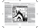
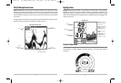
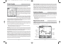
Combo View
Depth
Depth
Cartography
Sonar Window
Bearing of Boat
with Respect to
True North
Water Surface
Temperature
Speed of Boat
Map Scale
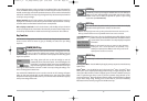
Chart View (with optional-purchase GPS receiver)
Chart View - This view is only available if you have purchased and connected a GPS Receiver, and
shows cartography from the built-in World Map or an optional MMC map for the area surrounding
your current position. The current track (also known as the position history or breadcrumb trail)
showing where the boat has been, along with saved tracks, waypoints, and the current route
(when navigating), are overlaid on the chart. You can use the 4-WAY Cursor Control key to
shift/pan the chart to another area. You can use the ZOOM (+/-) keys to zoom in and out. You can
use the INFO key to get information on the chart objects near the cursor.
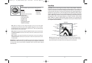
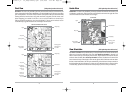
Chart View with Active Cursor
Depth
Cartography
Latitude and
Longitude
Position of
Cursor
Bearing of Boat
with Respect to
True North
Distance to
the Cursor
and Bearing
to Cursor
Map Scale
Active Cursor
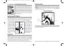
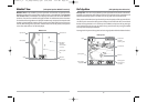
Chart View without Active Cursor
Depth
Cartography
Speed Of Boat
Bearing of Boat
with Respect to
True North
Water Surface
Temperature
Map Scale
21
531438-1_A - 737_EnglishOnly.qxd 9/25/2005 7:52 PM Page 28