


31
right appears. Now press the
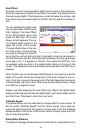
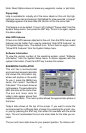
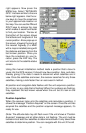
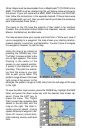
MENU key. Select “INITIALIZE
GPS”. A screen similar to the one
below right appears. Use the ar-
row keys to move the crosshairs
to your approximate location on
the map. You can use the ZIN and
ZOUT keys to enlarge the map
which makes it easier and faster
to find your location. The box at
the bottom of the screen shows
the latitude and longitude of the
cursor position. A box pops up on
the screen, showing the name of
the nearest highway (if a MMC
with a map is installed) along with
the distance and bearing from the
last known position. Once you
have the crosshairs on your lo-
cation, press the ENT key. The
unit returns to the satellite status
screen.
Using this manual initialization method loads a position that’s close to
yours into the GPS receiver. It should now have position, time, and date,
thereby giving it the data it needs to determine which satellites are in
view. Once the satellites are known, the receiver searches for only those
satellites, making a lock faster than an auto search method.
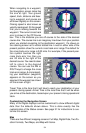
All position and navigation data flashes until the unit acquires a position.
Do not rely on any data that is flashing! When the numbers are flashing,
they represent the last known values when the unit lost it’s lock on the
satellites.
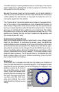
Position Aquisition
When the receiver locks onto the satellites and calculates a position, it
shows the message “Position Acquired” on the screen. Once the unit has
acquired the satellites and the position acquired message appears, it’s
ready for use.
(Note: The altitude data may still flash even if the unit shows a “Position
Acquired” message and all other data is not flashing. The unit must be
locked onto at least four satellites to determine altitude. It only takes three
satellites to determine position. You can navigate with this unit if the alti