


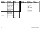
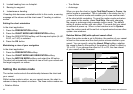

Menu item Description Options
Nav. Marks Symbols Determines which set of
navigation marksymbols
is used — International,
or US. These symbols
correspond to paper
charts.
• International (default)
• US
Light Sectors
Determines whether
the sector of light cast
by a xed beacon is
displayed or not.
• OFF — sector of light
is NOT displayed.
• ON — sector of light
is displayed.
• OFF
• ON (default)
Caution & Routing
Data
Determines whether
caution and routing data
is displayed or not.
• OFF — caution and
routing data is NOT
displayed.
• ON — caution
and routing data
is displayed.
• OFF
• ON (default)
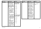
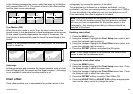
Menu item Description Options
Marine Features When this menu item
is set to ON, the
following water-based
cartographic features
are displayed:
• Cables.
• Nature of seabed
points.
• Tide stations.
• Current stations.
• Port information.
• OFF
• ON (default)
Land Features When this menu item is
set to ON, land-based
cartographic features
are displayed.
• OFF
• ON (default)
Colored Seabed Areas
When this menu item is
set to ON, the seabed
is shown in greater
denition in certain
areas where the extra
detail is available.
• OFF (default)
• ON
Background Color
Determines what color
the background water
will be in any areas
where Navionics
cartography is not
available.
• White (default)
• Blue
58 C-Series Widescreen user reference