


Y1-03-0211 Rev D 18
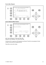
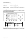
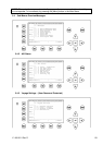
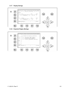
This information indicates the Reference Point of the used GPS Antenna onboard the
vessel.
RefPoint:A190 B120 C10 D<63m
A: 190m
B: 120m
C: 10m
D: >63m (means more than 63m in the case of a very large vessel)
Vessels Cargo:
Indicates the type of cargo on board.
N/A or harmless
Further Vessel Details:
Draught : 3.3m
Dest : HAWAII
ETA : 10/15 12:31
NavSt : Moored
Information on the vessel’s Equipment Position Finding Device:
EPFDType: GPS
Position Accuracy and Data Terminal Equipment (DTE):
PosAcc :High <10m
DTE :Available
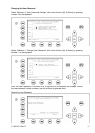
This information indicates that the vessels Transponder is connected with a user interface
and can show AIS Data. This function basically ensures that the current Transponder being
used is fitted with a display and can therefore send and receive messages. As the
NAUTICAST
Press [Enter] for more details in next view:
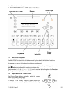
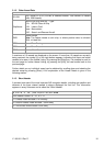
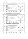
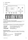
Additional Inland Vessel details:
European Vessel Identification Number (ENI):
ENI : 04401020
Blue Sign: N/A means ship do not have a Blue Sign
Blue Sign: N/A
Additional Inland Vessel dimension and information:
Length: 27.5m Beam: 5.5m
Drauth: N/A
Convoy: 8490 – Bunkership [ERI Ship Type]
Load: unloand Hazardas: N/A
Quality: Speed: Lo Course: Lo Heading: Lo
Persons on Board:
Crew: 2 Support: 1
Int’l: 4 Passengers: 1
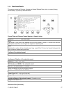
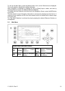
3.2 Menu Structure