


Y1-03-0211 Rev D 36
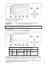
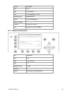
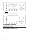
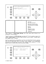
Reference Point (in meters):
This information indicates the Reference Point of the used GPS Antenna onboard the
vessel.
RefPoint: A190 B120 C10 D>63m
A: 190m
B: 120m
C: 10m
D: >16m
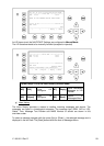
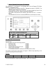
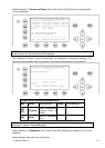
Vessels Cargo:
Indicates the type of cargo on board
N/A or harmless
Further Vessel Details:
Draught : 3.3m
Dest : HAWAII
ETA : 10/15 12:31
NavSt : Moored
Information on the vessel’s Equipment Position Finding Device:
EPFDType: GPS
Position Accuracy and Data Terminal Equipment (DTE):
PosAcc :High <10m DTE :Available
The accuracy of the position is higher than 10 m (= High <10m), the opposite would be less
than 10m (= Low >10m). This information indicates that the vessels Transponder is
connected with a user interface and can show AIS Data. This function basically ensures that
the current Transponder being used is fitted with a display and can therefore send and
receive messages.
As the NAUTICAST
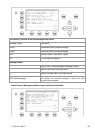
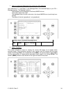
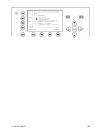
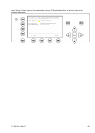
Additional Inland Vessel details:
European Vessel Identification Number (ENI):
ENI : 0IR44070
Blue Sign: N/A means ship does not have a Blue Sign (see chapter: 3.5.4 f)
Blue Sign: N/A
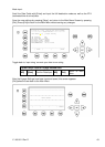
Additional Inland Vessel dimension and information:
Length: 27.5m Beam: 5.5m
Drauth: 7.1m
Convoy: 8444 - Pass.ship no accomodat
Load: unloand Hazardas: N/A
Quality: Speed: Lo Course: Lo Heading: Lo
Persons on Board:
Crew: 2 Support: 1
Int’l: 4 Passengens: 1
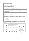
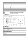
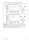
l) Version Info
This Screen shows the actual Software Release which is being run on the NAUTICAST.