


78
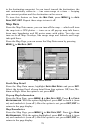
to the destination waypoint. As you travel toward the destination, the
unit automatically zooms in — one zoom range at a time — keeping
your current position and the destination on the screen.
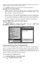
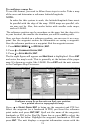
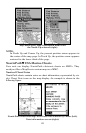
To turn this feature on from the
MAP PAGE, press MENU|↓ to AUTO
ZOOM|ENT|EXIT. Repeat these steps to turn it off.
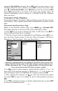
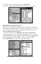
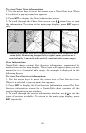
Map Data
From the Map Data menu, you can turn off the map — which will turn
the map into a GPS plotter — turn on or off pop-up map info boxes,
draw map boundaries and fill water areas with white. You also can
turn on or off Map Overlays, like range rings and latitude and longi-
tude grid lines.
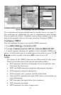
From the Map Page, you can access the Map Data menu by pressing
MENU|↓ to MAP DATA|ENT.
Map Data Menus
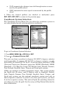
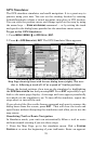
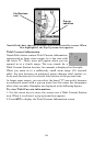
Earth Map Detail
From the Map Data menu, highlight
EARTH MAP DETAIL and press ENT.
Select the desired level of map detail from four options: Off, Low, Me-
dium or High. After the option is set, press
EXIT.
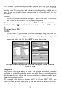
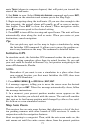
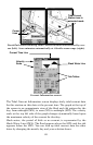
Pop-up Map Information
From the Map Page, press
MENU|↓ to MAP DATA|ENT. Press ↓ to POPUP
MAP INFORMATION. With the option highlighted, press ENT to check it (turn
on) and uncheck it (turn off.) After the option is set, press
EXIT|EXIT to
return to the page display.
Map Boundaries
From the Map Page, press
MENU|↓ to MAP DATA|ENT. Press ↓ to DRAW
MAP BOUNDARIES. With the option highlighted, press ENT to check it (turn
on) and uncheck it (turn off.) After the option is set, press
EXIT|EXIT to
return to the page display.