


19
Canceling watchman
Press any key while the radar is transmit-
ting. (Pressing a key during stand-by causes
the radar to go to warm-up condition.)
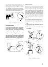
2.27 Erasing the Heading
Marker
The heading marker continuously appears
on the display and shows your vessel’s head-
ing. When this mark obscures a target echo,
you can temporarily erase it by pressing and
holding down the [HM OFF] key. Release
the key to redisplay the marker.
2.28 Deselecting Ranges
This radar has 15 ranges, some which you
may not require. You can deselect up to eight
ranges as follows.
1) Press the [MENU] key.
2) Select Mode & Function and press the
[ENT] key.
3) Select Range and press the [ENT] key.
Active ranges appear in reverse video.
4) Press t or s to select range to disable
(or enable). Current selection is under-
lined.
5) Press [ENT].
6) Repeat steps 4 and 5 to disable (or en-
able) other ranges.
7) When finished, press the [MENU] key.
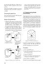
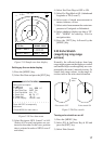
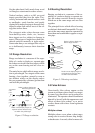
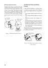
2.29 Displaying Navigation
Data During Stand-by
Various navigation data can be displayed
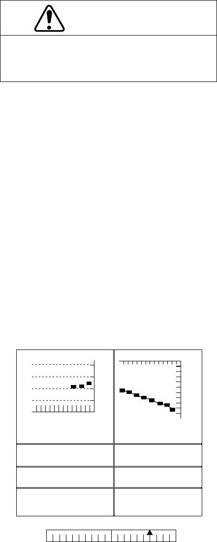
during stand-by. A barometer is built in this
radar; atmospheric pressure appears, in
graph form, on the navigation data display
during stand-by. If your navigation aid can
output data in NMEA 0183 data format, your
CAUTION
The barometer and depth displays are intended
as reference. Any data displayed by them
should be used with extreme caution.
vessel’s position in latitude and longitude,
the range and bearing to waypoint, speed,
course, date, time and cross track error may
be input to this radar, and be seen in the bot-
tom text area during stand-by. Further, with
video sounder input, depth may be dis-
played, both digitally and in graph form.
Procedure
1) Press the [MENU] key.
2) Select the Nav Data menu and press the
[ENT] key.
3) Select STBY Display to NAV and press
the [ENT] key.
4) Press the [MENU] key.
Note 1: The depth display scale changes au-
tomatically with depth and the maximum depth
is 1,000 meters.
Note 2: The barometer display is updated
hourly, thus the data shown may not be the
latest.
DATE TIME TEMP CRS
08.22 15:19 30.0
°C
0.0°M
DEPTH XTE SPD
827 m 0.6NM R 30.0KT
WAYPOINT POSI L/L
65°43.98N
165°43.96E
XTE
110
0.5
0.5
XTE
(NM)
LR
BAROMETER DEPTH
0
500
1000
(m)
12
(MIN)
-12
-9 -6 -3
1020
1010
1000
990
(HOUR)
(Mbar/hPa)
ST–BY
12.0NM 114.8°R
Figure 2-22 Navigation data display
during stand-by