


9. VECTOR (S57) CHARTS
9-2
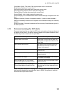
9.1.1 Definitions of terms
9.1.2 Chart legend for S57 charts
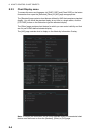
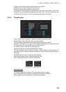
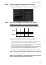
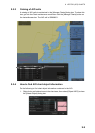
The chart legend provides various data about the chart currently displayed. To find
info for current position, turn on TM reset, then click the [Chart INFO] button on the
InstantAccess bar followed by the [Chart Legend] button, in the Voyage planing mode
or Voyage navigation mode. To find info for a specific location, put the cursor on the
location then right-click and select [Chart Legend]. Click the [Close] button to close the
display.
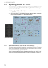
This system is capable of showing more than one S57 chart at a time. This feature is
called the multi-chart display. If one S57 chart does not cover the whole display, the
system will open more S57 chart cells for display, if appropriate cells for the displayed
area are available. The chart legend shows information about S57 charts displayed on
the electronic chart display area.
[Name]: Name of chart.
[Source]: Source of chart.
[Edition]: Edition number of the chart.
[Edition Date]: Date the edition was published.
[Update Number]: Update number.
[Update Date]: Date of update.
Cell A cell is a geographical area containing ENC data and it is the smallest di-
vision of ENC data. Each cell has a separate unique name. Hydrographic
Offices divide their responsibility area by the cells that they publish.
S57 chart A database, standardized as to content, structure and format, is issued for
use with this system without any authority of government-authorized Hydro-
graphic Office.
ENC A database, standardized as to content, structure and format, is issued for
use with this system on the authority of government-authorized Hydro-
graphic Offices. The ENC contains all the chart information necessary for
safe navigation and may contain supplementary information in addition to
that contained in the paper chart (e.g., sailing directions) that may be con-
sidered necessary for safe navigation. The name of the coding standard for
ENC is S57ed3.
SENC A database resulting from the transformation of the ENC by the system for
appropriate use, updates to the ENC by appropriate means, and other data
added by the mariner. It is this database that is actually accessed by the
system for display and other navigational functions. The SENC may also
contain information from other sources.