


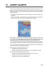


11. CHART ALERTS
11-2
11.1 Chart Alerts
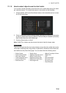
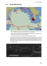
Official S57 chart material contains depth contours that can be used for calculation of
chart alerts. A chart database also includes different types of objects that the operator
can use for chart alerts. The procedure for setting chart alerts is outlined below.
1. Select suitable safety contour for your own ship. See paragraph 11.1.1 for how to
set the safety contour.
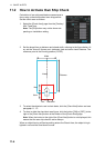
2. In the Voyage planning mode, define a new route or select an existing one. Make
a chart alert calculation of the route if there are indications of danger areas in the
route. Modify your route if necessary and do the chart alert calculation again. To
modify an existing route see section 12.4.
3. Select route as monitored route.
4. Set check area for your own ship.
The system is now ready for chart alert calculation of monitored route and estimated
own ship position.
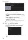
11.1.1 How to set safety contour
Select safety contour suitable for the own ship.
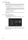
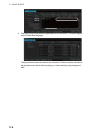
1. Click the [DISP], [SET] and [Chart Alert] buttons on the InstantAccess bar to show
the [Chart Alert] page.
2. Enter desired depth at [Safety Contour] then click the [Save] button.
A depth contour is created on the chart according to the safety contour value entered.
Note: If the chart does not contain chosen depth contour, the system will automatically
select next deeper contour.