


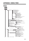
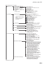
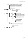
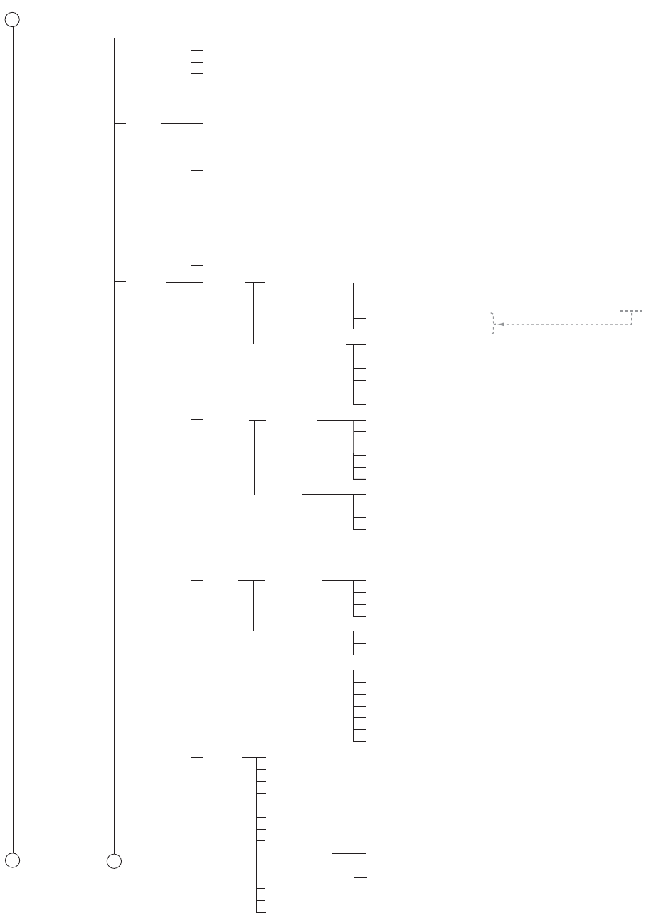
APPENDIX 1 MENU TREE
AP-6
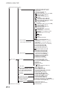
Standard*
1
(Checkbox for each of Unknown Object or Presentation; Chart
Data Coverage; Standard Land Features; Water and Seabed Features;
Traffic Routes; Cautionary Areas; Information Areas; Buoys and
Beacons; Lights; Fog Signals; Radar; Services)
Other*
2
(Checkbox for each of Information about Chart Data; Other Land
Features; Soundings; Depth Contour Labels; Depth Contours,
Magnetics, Currents; Seabed, Pipelines and Obstructions; Obstructions
with Soundings; Service and Small Craft Facilities; Low Accuracy;
Special Areas; Additional Information Available; Clearance, Bearings,
Radio Channels; Other Text; Names for Position Report; Light
Descriptions; Seabed; Swept Depth, Magnetics; Berth and Anchorage;
Geographic Names, etc.; Land Elevation)
AIO*
2
(Checkbox for Temporary Notice; Preliminary Notice; No Information)
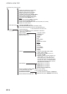
DISP Basic
Setting
Symbols (Paper Chart, Simplified)
Depths (Two Color, Multi Color)
Boundaries (Plain, Symbolized)
Lightsectors (Limited, Full)
Shallow Pattern (None, Diamond)
Shallow Hazard (OFF, ON)
TM Reset (20 to 99, 80%)
General Ship Outlines
Chart
Display
Symbol
Display
Ship Vectors (ON, OFF)
Target Vectors (ON, OFF)
Style (std ECDIS, Conventional)
Time Increments (Checkbox unchecked)
Path Predictor (Checkbox unchecked)
Radar Antenna (Checkbox unchecked)
Tracking
Own Ship
Past Tracks
CCRP (Checkbox unchecked)
Primary (Checkbox unchecked)
Secondary (Checkbox unchecked)
Style (Tick, Point)
Length (1-120 min, 1)
Labels (0-60 min, 0)
Events
User Events (Checkbox unchecked)
Auto Events (Checkbox unchecked)
Positions (Checkbox unchecked)
Show (Newer than 12 hours, Newer
than 24 hours, Newer than 1 week,
Newer than 2 weeks, Newer than 1
month, Newer than 3 months, All)
Route
Monitored
Route
Channel Limit (Checkbox unchecked)
Safety Margin (Checkbox unchecked)
Leg Marks (Checkbox unchecked)
Wheel Over Line (Checkbox unchecked)
Planned
Route
Channel Limit (Checkbox unchecked)
Safety Margin (Checkbox unchecked)
Leg Marks (Checkbox unchecked)
Mariner
User Chart
Labels (Checkbox unchecked)
Lines (Checkbox unchecked)
Clearing Lines (Checkbox unchecked)
Tidals (Checkbox unchecked)
Areas (Checkbox unchecked)
Circles (Checkbox unchecked)
Transparent (25%, 50%, 75%, No color fill)
Targets
Color (Green, Blue, Black, Magenta, Brown)
AtoN Symbol Color (Green, Blue, Black, Magenta, Brown)
TT Size (Standard, Small)
AIS ROT TAG Limit (0.0°/min to 720.0°/min, 0.0)
TT Label (ON, OFF)
AIS Label (ON, OFF)
TT Pop-up INFO (ON, OFF)
AIS Pop-up INFO (ON, OFF)
Past Position
AIS Base Station (ON, OFF)
AIS Physical AtoN (ON, OFF)
AIS Virtual AtoN (ON, OFF)
TT Points (5, 10)
AIS Points (5, 10)
Style (Points, Points and dots)
*1: All checked
*2: All unchecked
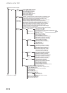
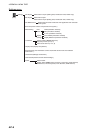
1
1
2
(Continued from previous page)
(Continued on next page)
Setting
Ship Outlines (ON, OFF)
AIS Outlines (ON, OFF)
True outlines shown if (Set length and beamwidth.) > limit
Own Ship Limit*
3
= 3 mm
AIS Limit*
3
= 3 mm
Velocity Vectors
*3: Display only