


2. OPERATION
2-14
2.9 System Setup
2.9.1 Geodetic data
Your unit is preprogrammed to recognize most of the major chart systems of the
world. Although the WGS-84 system (default setting) is the GPS standard, other
categories of charts in other datum still exist. Match the GPS datum with the
chart system you use.
1. Press the [MENU] key to open the menu.
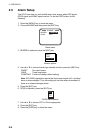
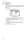
2. Choose SYS SETUP and then press the [ENT] key.
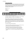
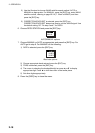
SYSTEM SETUP
DATUM : WGS84
UNITS : kn
TIME DIFF
: +00:00
TIME DISP : 24 HOUR
TEST?
DEMO : OFF
EXCHANGE BATTERY?
SYSTEM SETUP menu
3. Confirm that the cursor is selecting DATUM and then press the [ENT] key.
4. Choose WGS84 (GPS standard), WGS72 or OTHER according to the
nautical chart you use and then press the [ENT] key.
5. If you chose WGS72 or WGS84, press the [DISP] key to finish. For OTHER,
go to step 6.
6. Press the [ENT] key.
7. Use the Omnipad to enter chart number, referring to the geodetic chart list on
page A-2. Choose location with ◄ or ►; change value with ▲ or ▼.
8. Press the [ENT] key.
9. Press the [DISP] key to close the menu.