


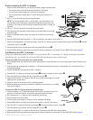
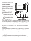
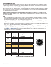
8 GPSMAP 6000/7000 Series Installation Instructions
Installing the GPSMAP 6000/7000 Series Chartplotter and the GPS 17x Antenna NMEA
2000 Network Connections
The GPSMAP 6000/7000 series chartplotter is packaged with the necessary NMEA 2000 connectors and cable to either connect a GPSMAP
6000/7000 series chartplotter and a GPS 17x antenna to your existing NMEA 2000 network, or to build a basic NMEA 2000 network. For more
information on NMEA 2000, visit www.garmin.com.
If you are unfamiliar with NMEA 2000, be sure to read the “NMEA 2000 Network Fundamentals” chapter of the Technical Reference for
Garmin NMEA 2000 Products on the included CD or click on the “Manuals” hyperlink on the product page for your chartplotter at www.
garmin.com. For example, www.garmin.com/products/GPSMAP7212/.
Connecting to an Existing NMEA 2000 Network
If your boat already has a NMEA 2000 network installed, use the included T-connectors and drop cable to connect a GPSMAP 6000/7000 series
chartplotter and a GPS 17x antenna to the existing network.
Notice
If you have an existing NMEA 2000 network on your boat, it should already be connected to power. Do not connect the included NMEA 2000
power cable to an existing NMEA 2000 network.
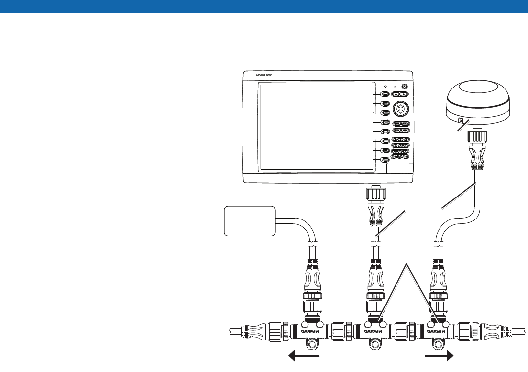
To connect a GPSMAP 6000/7000 series chartplotter and a GPS 17x to your existing NMEA 2000 network:
1. IdentifywhereyouwanttoconnecttheGPSMAP
6000/7000 series chartplotter and the GPS 17x to your
existing NMEA 2000 backbone.
2. Disconnect one side of a NMEA 2000 T-connector from
the backbone nearest to the location where you want to
connect the chartplotter.
To extend the NMEA 2000 backbone (if necessary),
connect an appropriate NMEA 2000 backbone extension
cable (not included) to the side of the T-connector you
disconnected.
3. Connect an included T-connector to the NMEA 2000
backbone (for the chartplotter).
4. Route an included drop cable to the chartplotter and
to the top of the T-connector you added to your NMEA
2000 network.
Iftheincludeddropcableisnotlongenough,youcan
addadropcableextensionupto13ft.(4m).Ifmore
cable is needed, add an extension to your NMEA 2000
backbone, based on the NMEA 2000 guidelines.
5. Disconnect one side of a NMEA 2000 T-connector from
the backbone nearest to the location where you want to
connect the GPS 17x antenna.
To extend the NMEA 2000 backbone (if needed),
connect an appropriate NMEA 2000 backbone extension
cable (not included) to the side of the T-connector you
disconnected.
6. Connect
an included T-connector in the NMEA 2000
backbone (for the GPS 17x antenna).
7. Route an included drop cable from the GPS 17x antenna to the top of the T-connector you added to your NMEA 2000 network.
Iftheincludeddropcableisnotlongenough,youcanaddadropcableextensionupto13ft.(4m).Ifmorecableisneeded,addan
extension to your NMEA 2000 backbone, based on the NMEA 2000 guidelines.
NOTES:
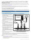
The diagram on page 8 shows only the NMEA 2000
data connection to a GPSMAP 6000/7000 series chartplotter. The chartplotter must
also be connected to power or it will not function.
One GPS antenna will provide position data for every device on the NMEA 2000 network. Do not connect multiple GPS antennas if you
are using multiple chartplotters.
•
•
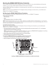
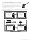
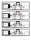
Connecting a GPSMAP 6000/7000 Series Chartplotter and a GPS 17x
Antenna to an Existing NMEA 2000 Network
T-connectors
(included)
Drop cables
(included)
Existing NMEA 2000 network
(not included)
GPS 17x
antenna
GPSMAP 6000/7000
series chartplotter
NMEA 2000
device
(not included)
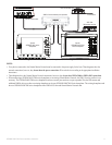
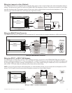
Connecting a GPSMAP 6000/7000 Series Chartplotter and a GPS 17x
Antenna to an Existing NMEA 2000 Network
T-connectors
(included)
Drop cables
(included)
Existing NMEA 2000 network
(not included)
GPS 17x
antenna
GPSMAP 6000/7000
series chartplotter
NMEA 2000
device
(not included)