


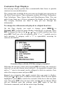
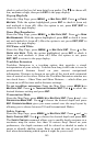
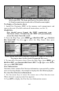
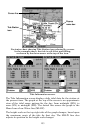

149
Entrance to Chesapeake Bay in a MapCreate 6 custom map with a 10-
mile zoom (left). The same position on Navionics chart at
11.15-mile zoom (center) and with a 5.56-mile zoom (right).
To display a Navionics chart:
1. Install the Navionics MMC in the memory card compartment and
turn on the unit. (For full card install instructions, see Sec. 2.)
WARNING:
You should never format the MMC containing your
Navionics chart. Formatting the MMC will permanently
erase the chart from the card.
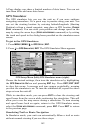
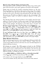
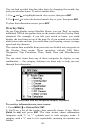
2. From the Map Page, press
MENU|↓ to MAP DATA|ENT|→ to NAVIONICS
MAP CHOICE|ENT. Use ↑ or ↓ to select the Map Name, then press
ENT|EXIT|EXIT.
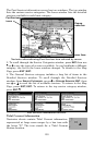
These figures show menu sequence (from left to right) for selecting a
Navionics chart for the South Chesapeake Bay area.
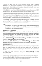
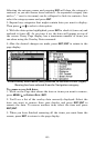
3. To turn off a Navionics chart, From the Map Page, press MENU|↓ to
MAP DATA|ENT|→ to NAVIONICS MAP CHOICE|ENT. Use ↑ or ↓ to select EAGLE,
then press
ENT|EXIT|EXIT.
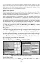
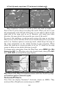
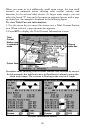
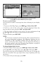
Port Information
Navionics charts contain Port Services information, represented by anchor
icons on the map display. An example is displayed in the following figure.
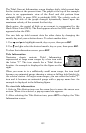
To view Port Services information:
1. Use the arrow keys to move the cursor over a Port Services icon.
When selected, a pop-up name box appears.
2. Press
WPT to display the Port Services Information screen.