


141
Map Fix
Map Fix is used with charts or maps. This system asks for a reference
position in latitude/longitude, which you take from a marked location
on the map. It then shows the present position as distance on the map
from that reference point.
For example, if it shows a distance of UP 4.00" and LEFT 0.50", you
then measure up four inches and to the left a half-inch from the refer-
ence point on the map to find your location.
To configure a map fix:
To use this format, you need to follow these steps in order. First, take
your map of the area and determine a reference latitude/longitude.
(Note: in order for this system to work, the latitude/longitude lines
must be parallel with the edge of the map. USGS maps are parallel,
others may not be. Also, this works better with smaller scale maps.)
The reference position can be anywhere on the map, but the closer it is
to your location, the smaller the numbers will be that you'll have to
deal with.
Once you've decided on a reference position, you can save it as a way-
point. See the waypoint section for information on saving a waypoint.
Save the reference position as a waypoint. Exit from the waypoint
screens.
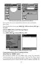
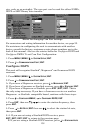
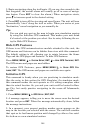
1. Press
MENU|MENU|↓ to GPS SETUP|ENT.
2. Press ↓ to
COORDINATE SYSTEM|ENT.
3. Press ↓ to
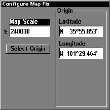
SETUP MAP FIX|ENT.
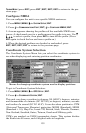
The screen below appears, and
MAP SCALE is highlighted. Press ENT and
enter the map's scale. This is generally at the bottom of the paper map.
It's shown as a ratio, for example 1:24000. Press
EXIT and the unit re-
turns to the Configure Map Fix screen.
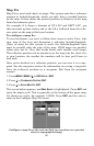
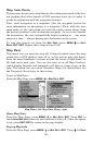
Configure a map fix so the unit can find your position on a printed
chart or topographical map.