


149
To change map orientation: from the Map Page, press
MENU|↓ to MAP
ORIENTATION|ENT. Use ↑ or ↓ to select the desired mode, then press ENT.
Press
EXIT|EXIT to return to the page display.
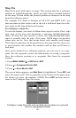
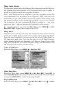
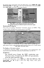
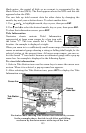
Map Menu, left; Map Orientation menu with
the North Up map orientation option selected, right.
Navionics
Charts
Your unit can display Navionics
electronic charts on MMCs. They
work just like a MapCreate custom map on an MMC.
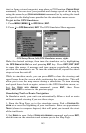
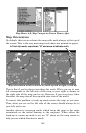
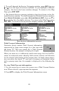
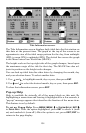
Left, entrance to Chesapeake Bay in a MapCreate 6 custom map, 10
mile zoom. Center, same position on Navionics chart at 11.15 mile zoom
and right, 5.56 mile zoom.
To display a Navionics chart:
1. Install the Navionics MMC in the memory card compartment and
turn on the unit. (For full card install instructions, see Sec. 2.)
WARNING:
You should never format the MMC containing your
Navionics chart. Formatting the MMC will permanently
erase the chart from the card.
2. From the Map Page, press
MENU|↓ to MAP DATA|ENT|↓ to MAP
CHOICE|ENT. Use ↑ or ↓ to select the Map Name, then press
ENT|EXIT|EXIT.