


1. OPERATION
15
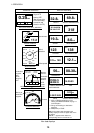
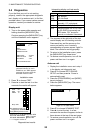
GRAPHIC DISPLAYS DIGITAL DISPLAYS
1 0.5 0 0.5 1
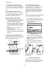
Waypoint 03
Rng 0.19nm Brg 321°
XTE 0.00nm Cse 333°
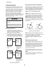
DESTINATION WAYPOINT GRAPHIC
XTE
scale
Bearing,
Course
Destination
waypoint
direction
Destination
waypoint
data:
Name,
Range to,
XTE
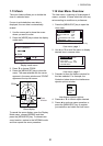
Wind
APP*
WIND GRAPHIC
60
120
90
0
30
150
180
120
150
90
60
30
120°
Speed 10.3 m/s
COMPASS GRAPHIC
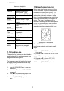
SPEED GRAPHIC
17.2
Speed
20
50
40
60
30
10
0
Course
123
°
COURSE
Depth
32.8ft
DEPTH
Heading
MAG#
HEADING
Odometer
56nm
ODOMETER
Position
30° 00.065'N
130° 00.574'E
POSITION
Temperature
69.8°F
WATER TEMPERATURE
Trip meter
12.1nm
TRIP DISTANCE
Time to Go
00H30M
TIME-TO-GO**
Speed
19.3kt
SPEED
Range
1.21
nm
RANGE & BEARING**
Bearing
140
°
Wind Speed
APP*
WIND SPEED
Wind Direction
APP*
WIND DIRECTION
kt
Bearing to
destination
waypoint
Course
Brg
30°
Cse
90°
N
E
* = APP or TRUE depending on menu
setting. See WIND SPD/DIR on page 17
for description.
** = Range and bearing to destination
waypoint
# = MAG(netic) or TRUE.
Speedometer
Note 1: The graphic data selected on the
standby display is shown as digital data on the
TX display.
Note 2: "- -" appears when data from
corresponding sensor is lost for 90 sec.
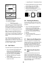
TD
31234.5
56432.6
LORAN C/DECCA TIME
DIFFERENCES
TIME
Time
14:25:03
Wind
direction
Wind speed
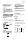
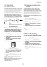
XTE (Cross-Track Error) GRAPHIC
1 0.5 0 0.5 1
0.25
nm
XTE
Digital XTE
Analog XTE
(Bar moves right
or left according
to amount and
direction of XTE)
318
°
8.0m/s
138
°
Date
XTE
CROSS-TRACK ERROR
19 SEP 2003
DATE
0.24
nm
1 0.5 0 0.5 1
Nav data displays