


27
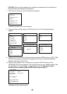
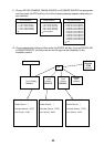
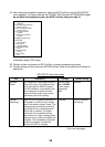
NAV SETUP menu description
Item Description Settings (Default in bold)
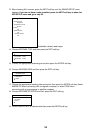
Position
Source
Chooses source of position data.
FURUNO BB GPS: GPS Receiver
GP-320B/330B or Weather sensor
WS-200
GP: GPS navigator (via
NETWORK or NMEA port)
LC: Loran C navigator (via
NETWORK or NMEA port)
ALL: Multiple navaid connection
(via NETWORK or NMEA port)
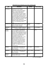
Speed (STW)
Source
Chooses source of speed data ETR (NavNet sounder), NMEA
Temperature
Source
Chooses source of water temperature data. ETR, NMEA. Select ETR to show
water temperature data fed from
the network sounder.
Depth
Source
Chooses source of depth data. ETR, NMEA. Select ETR to show
depth data fed from the network
sounder.
STW
Calibration
Calibrates NMEA speed data. Enter amount
in percentage.
-50 to +50%, 00%
Temp
Calibration
Calibrates NMEA temperature data. Enter
offset to correct NMEA temperature data.
-20.0°C to +20.0°C (or equivalent
in °F), 00.0°C
Depth
Calibration
Calibrates NMEA depth data. Enter offset to
correct NMEA depth data.
-15 to +90 ft (or equivalent in m, fa
or P/B). 00 ft
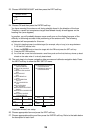
Wind
Averaging
Enter a value to smooth wind
speed/direction data. Ship’s bow is
referenced to smooth wind vector
movement.
001-600 s, 001 s
Wind
Direction
Offset
Offsets wind direction data. S180°-P180°, S000.0°
Wind Speed
Calibration
Offsets NMEA wind speed data. Enter
amount in percentage.
-50 to +50%, 00%
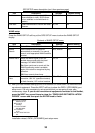
Wind (MWV)
Source
Chooses source of wind data. FURUNO BB GPS, NMEA: Select
FURUNO BB GPS to show wind
data fed from the WS-200.
Air
Temperature
Source
Chooses source of air temperature data. FURUNO BB GPS, NMEA: Select
FURUNO BB GPS to show air
temperature data fed from the
WS-200.
Air Pressure
Source
Chooses source of air pressure data. FURUNO BB GPS, NMEA: Select
FURUNO BB GPS to show air
pressure data fed from the
WS-200.