


APPENDIX 4 DIGITAL INTERFACE
AP-10
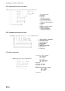
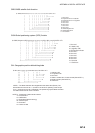
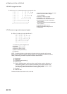
GNS-GNSS fix data
$--GNS,hhmmss.ss,llll.ll,a,yyyyy.yy,a,c--c,xx,x.x,x.x,x.x,x.x,x.x,a*hh<CR><LF>
| | | | | | | | | | | | | |
| | | | | | | | | | | | | +--- 12
| | | | | | | | | | | | +------- 11
| | | | | | | | | | | +----------- 10
| | | | | | | | | | +---------------- 9
| | | | | | | | | +--------------------- 8
| | | | | | | | +------------------------- 7
| | | | | | | +------------------------------ 6
| | | | | | +--------------------------------- 5
| | | | | +--------------------------------------- 4
| | | +-----+------------------------------------------- 3
| +--+--------------------------------------------------------- 2
+------------------------------------------------------------------------- 1
1. Not used
2. Latitude, N/S
3. Longitude, E/W
4. Mode indicator (See NOTE 2.)
5. Not used
6. Not used
7. Not used
8. Not used
9. Not used
10. Not used
11. Navigational Status Indicator
(See NOTE 1.)
12. Checksum
NOTE 1: Mode indicator. A variable length valid character field type with the first three characters
currently defined. The first character indicates the use of GPS satellites, the second character
indicates the use of GLONASS satellites and the third indecates the use of Galileo satellites. If another
satellite system is added to the standard, the Mode indicator will be extended to four characters. New
satellite systems should always be added on the right, so the order of characters in the Mode indicator
is: GPS, GLONASS, Galileo, other satellite systems in the future. The characters should take one of
the following values:
A = Autonomous. Satellite system used in non-differntial mode in position fix
D = Differential. Satellite system used in differential mode in position fix
E = Estimated (dead reckoning) mode
F = Float RTK. Satellite system used in real time kinematic mode with floating integers
M = Manual input mode
N = No fix. Satellite system not used in position fix, or fix not valid
P = Precise. Satellite system used in precision mode. Precision mode is defined as: no deliberate
degradation (such as selective availability) and higher resolution code (P-code) is used to compute
position fix. P is also used for satellite system used in multi-frequency, SBAS or Precise Point
Positioning (PPP) mode.
R = Real Time Kinematic. Satellite system used in RTK mode with fixed integers
S = Simulator mode
The Mode indicator should not be a null field.
NOTE 2: The navigational status indicator is according to IEC 61108 requirements on ‘Navigational (or
Failure) warnings and status indications’. This field shoule not be a NULL field and the character
should take one of the following values:
S = Safe When the estimated positoning accuracy (95 % confidence) is within the selected
accuracy level corresponding to the actual navigation mode, and integrity is available
and within the requirements for the actual navigation mode, and a new valid position
has been calculated within 1 s for a conventional craft and 0.5 s for a high speed craft.
C = Caution When integrity is not available
U = Unsafe When the estimated positioning accuracy (95 % confidence) is less than the selected
accuracy level corresponding to the actual navigation mode, and/or integrity is available
but exceeds the requirements for the actual navigation mode, and/or a new valid
position has not been calculated within 1 s for a conventional craft and 0.5 s for a high
speed craft.
V = Navigational status not valid, equipment is not providing navigational status indication.