


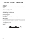


APPENDIX 4 DIGITAL INTERFACE
AP-12
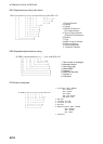
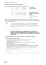
RMC-Recommended minimum specific GNSS data
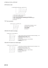
$--RMC,hhmmss.ss,A,llll.ll,a,yyyyy.yy,a,x.x,x.x,xxxxxx,x.x,a,a,a*hh<CR><LF>
| | | | | | | | | | | | | |
| | | | | | | | | | | | | +--- 10
| | | | | | | | | | | | +------- 9
| | | | | | | | | | | +--------- 8
| | | | | | | | +-------+-+----------- 7
| | | | | | | |
| | | | | | | +----------------------------- 6
| | | | | | +--------------------------------- 5
| | | | +---+------------------------------------ 4
| | +---+--------------------------------------------------- 3
| +------------------------------------------------------------ 2
+---------------------------------------------------------------------- 1
1. UTC of position fix
2. Status: A=data valid,
V=navigation receiver warning
(See NOTE 1.)
3. Latitude, N/S
4. Longitude, E/W
5. Speed over ground, knots
6. Course over ground, degrees tru
e
7. Not used
8. Mode indicator
(See NOTE 2 and 3.)
9. Navigational Status Indicator
10. Checksum
NOTE 3: The positioning system Mode indicator field supplements the positioning system status field,
the status field should not be set to V = Invalid for all values of Indicator mode except for A = Autonomou
s
and D = Differential. The positioning system Mode indicator and status fields should not be null fields.
A = Autonomous. Satellite system used in non-differential mode in position fix
D = Differential. Satellite system used in differential mode in position fix
E = Estimated (dead reckoning) mode
F = Float RTK. Satellite system used in real time kinematic mode with floating integers
M = Manual input mode
N = No fix. Satellite system not used in position fix, or fix not valid
P = Precise. Satellite system used in precision mode. Precision mode is defined as: no deliberate
degradation (such as selective availability) and higher resolution code (P-code) is used to
compute position fix. P is also used for satellite system used in multi-frequency, SBAS or
Precise Point Positioning (PPP) mode.
R = Real time kinematic. Satellite system used in RTK mode with fixed integers
S = Simulator mode
NOTE 2: Positioning system Mode indicator;
NOTE 1: The navigational status indicator is according to IEC 61108 requirements on ‘Navigational (or
Failure) warnings and status indications’. This field should not be a NULL field and the character should
take one of the following values:
S = Safe When the estimated positoning accuracy (95 % confidence) is within the selected
accuracy level corresponding to the actual navigation mode, and/or integrity is
available and within the requirements for the actual navigation mode, and/or a new
valid position has been calculated within 1 s for a conventional craft and 0.5 s for a
high speed craft.
C = Caution When integrity is not available
U = Unsafe When the estimated positioning accuracy (95 % confidence) is less than the selected
accuracy level corresponding to the actual navigation mode, and/or integrity is
available but exceeds the requirements for the actual navigation mode, and/or a new
valid position has not been calculated within 1 s for a conventional craft and 0.5 s for a
high speed craft.
V = Navigational status not valid, equipment is not providing navigational status indication.