


10. C-MAP CHARTS
10-3
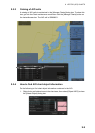
10.7 Chart Display
10.7.1 Introduction
C-MAP charts are S57 charts displayed together with ENC (S57) and CM93/3 charts.
These charts have the priority order shown below.
1. CM- ENC
2. C-MAP 93/3 Prof and C-MAP 93/3 Prof+
If the same navigational purpose charts are available over an area, priority is as shown
above. Areas where ENC is not available CM-ENC charts are shown. Where C-MAP
Prof or CM93 Prof+ are available, CM 93/3 charts are displayed.
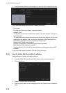
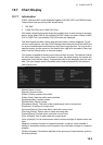
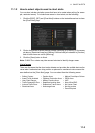
The chart legend provides various data about the chart currently displayed. To find
info for current position, click the [TM/CU Reset] button then click the [Chart INFO] but-
ton on the InstantAccess bar followed by the [Chart Legend] button. To find info for a
specific location, put the cursor on the location then right-click and select [Chart Leg-
end]. Click the [Close] button to close the display.
This system is capable of showing more than one chart at a time. This feature is called
the multi-chart display. If one chart does not cover the whole display, the system will
open more chart cells for display, if appropriate cells for the displayed area are avail-
able. The chart legend shows information about charts displayed on the electronic
chart display area.
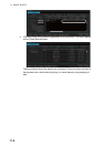
[Name]: Name of chart.
[Source]: Source of chart.
[Edition]: Edition number of the chart.
[Edition Date]: Date the edition was published.
[Update Number]: Update number.
[Update Date]: Date of update.
[Compilation Scale]: The scale of the original paper chart is shown here.
[Projection]: Projection of current chart.
[Horizontal Datum]: Horizontal datum used with current chart.
[Sounding Datum]: Datum used to create sounding data.
[Vertical Datum]: Vertical datum used with current chart.
[Units of Depth]: Unit of depth used with current chart.
[Units of Height]: Unit of measurement used to measure height of objects above sea
level.
[Magnetic Variation]: Amount of magnetic variation. A positive value indicates a
change in an easterly direction and a negative value indicates a change in a westerly
direction.
[Quality Indication]: Quantitative estimate of the accuracy of chart features, given by
the chart producer.
Chart Legend