


12. ROUTES
12-8
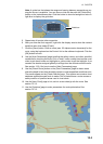
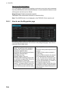
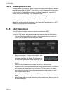
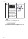
12.3.5 How to use the Check Results page
The [Check Results] page allows you to make safe water calculation for your route.
Click the [Check Route] button to do the check. After the button is operated, the alert
type and latitude and longitude position of the alert appear for applicable legs on the
route.
Note 1: In order to display charts with correct updated situation, always use current
date during your voyage. If your voyage lasts more than one week, set current date at
least once per week during your voyage.
Note 2: A route check can take longer with C-Map or CM-ENC charts. Wait until the
completion of the check.
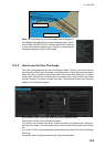
12.4 How to Modify an Existing Route
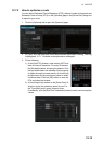
12.4.1 How to change waypoint position
To change position of a waypoint you have the following choices:
• Drag and drop waypoint using the left button.
• Enter latitude and longitude on the [Waypoints] page in the [Route Plan] dialog box.
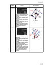
How to drag and drop waypoint to new position
1. Put the cursor on the route waypoint to move then push the right button to show
the context-sensitive menu.
2. Select [Edit].
3. Press and hold down the left button while rolling the trackball to move the cursor
to a desired position. Release the button when the cursor is at the desired posi-
tion. Right-click the display area to show the context-sensitive menu then select
[Finish].
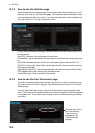
How to change latitude and longitude from the Waypoints page
1. Show the [Waypoints] page.
2. Put the cursor on the digit to change in the Latitude or Longitude field.
3. Enter position from the Control Unit’s keyboard, or spin the scrollwheel.