


12. ROUTES
12-10
12.4.6 Geometry check of route
When you add a new waypoint, modify a waypoint or change other waypoint data, the
message "Impossible turn at WPT" may appear (in red). It means that the geometry
of route makes it impossible for the ship to sail along a certain leg. Typically it is
enough if you do the following, on the [Waypoints] page.
• Decrease the radius of turn of the waypoint or one of its neighbors.
• Increase the radius of turn of the waypoint or one of its neighbors.
• Change lat/lon position of the waypoint or one of its neighbors.
Note: If the above-mentioned remedies do not remove the "Impossible turn at WPT"
indication, try changing the planned speed.
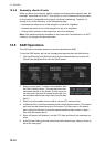
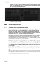
12.5 SAR Operations
The SAR feature facilitates search and rescue operations for MOB.
To use the SAR feature, get into the Voyage planning mode then do the following:
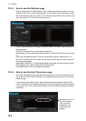
1. Click the [Planning] and [Route] buttons on the InstantAccess bar to show the
[Route Plan] dialog box then click the [SAR] button.
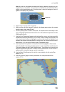
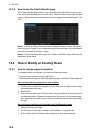
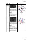
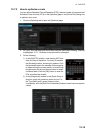
2. Enter your start point. To enter current position, click
the [Ship Position] button. (The start point can also
be entered directly on the screen. Put the cursor on
the start point, right-click the chart to show the con-
text-sensitive menu shown right then click [Set start
point].)
3. Enter your ship's speed and turn radius, current UTC date and time.
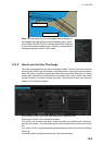
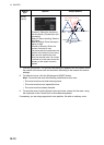
4. At [Search Point], enter the estimated position of the object to search. (The search
point can also be entered directly on the screen. Put the cursor on the search
point, right-click the chart to show the context-sensitive menu shown at step 2
then click [Set search point].
5. Enter drift speed, drift direction, and the UTC date and time of the estimated po-
sition.
6. At the [Search Setting] window, select and set the search type, referring to the ta-
ble on the next page.