


6. OTHER PLOTTER FUNCTIONS
28
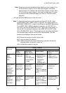
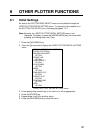
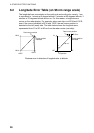
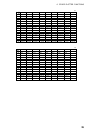
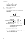
6.2 Longitude Error Table (on 96 nm range scale)
The longitude lines concentrate on the north pole and south pole, namely, 1 nm
is equivalent to 1 minute at 0 degree latitude, 2 minutes at 60 degrees latitude, 3
minutes at 70 degrees latitude and so on. For this reason, a longitude error
occurs on the radar display. For example, when own ship is at 60°N and 135°E,
even if the cursor indication is 62°N and 139°E, the real cursor position is
deviated to the left (west) side. The table below shows the longitude error,
represented from 0° to 90° at 96 nm from the radar center (own ship).
62°N °N
60°N
135°E
139°E
Real cursor position
Cursor position
indicated
LAT
E
Real cursor position
Cursor position
indicated
96 nm
θ
OS position
R: Error
Distance error in direction of longitude due to latitude