


SP - 1 E3047S01C
SPECIFICATIONS OF VIDEO PLOTTER
RP-250
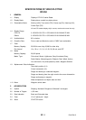
1 GENERAL
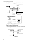
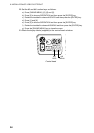
1.1 Display Display of FR-2115 series Radar
1.2 Display Mode Radar picture overlaid on plotter picture
1.3 Presentation Mode North up (NU), True motion (TM), Course up (CU), Head up (HU),
Cursor Gyro (CG)
HU and CG modes display ship’s course, marks and course line only.
1.4 Display Range
FR-2115: 0.125/0.25/0.5/0.75/1/1.5/2/3/4/6/8/12/16/24/34/48/72 NM
Others: 0.125/0.25/0.5/0.75/1/1.5/2/3/4/6/8/12/16/24/34/48/96 NM
1.5 Usable-latitude 80° or below
1.6 Coastline Data Furuno card and Navionics card or C-MAP card, selectable
1.7 Track
Memory Capacity 20,000 for own ship, 20,000 for other ship
Plot Interval 10 s, 30 s, 1, 2, 3, 6, 10, 20, 30, 60 min, and OFF
1.8 Marks
Memory Capacity 20,000 points
Marks’ Type Fish school, Wreck, Lighthouse, Buoy illuminated, Buoy,
Radio Station, Measuring point, Obstacle, Reef, Wharf, Anchor,
Line end mark, Line (three patterns), blank, Waypoint Number
1.9 Alphanumeric Data Indications
Own ship’s position (L/L)
Cursor intersection (L/L)
Range and bearing to a selected waypoint
Range and bearing from the origin mark to the cursor intersection
Range and bearing to waypoint
Water temperature and depth, date and time
1.10 Alarm Waypoint arrival alarm
2 AIS INDICATION
2.1 Symbol Sleeping/ Activated/ Dangerous/ Selected/ Lost targets
2.2 Number of Targets 1,000 max.
2.3 Data Indication Basic and Extended data
2.4 Track 10 or 5 points per 1 target
2.5 Alarm CPA/TCPA alarm